Ebsdorfergrund geodata
Ebsdorfergrund (Hesse) is a seat of a fourth-order administrative division; located in Germany in Europe/Berlin (GMT+2) time zone. In our database, there are 11009 cities with bigger population. Compared to other cities in Germany, 52.8% of cities are located further ↓South; 67.2% of cities are located further →East and 54.3% of cities have lower elevation than Ebsdorfergrund. Note1
Administrative division(s):
- Level 1: Hesse
- Level 2: Regierungsbezirk Gießen
- Level 3: Landkreis Marburg-Biedenkopf
- Level 4: Ebsdorfergrund


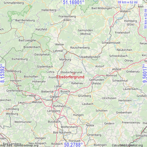
Ebsdorfergrund GPS coordinates[2]
50° 43' 33.672" North, 8° 51' 25.344" East
| Map corner | latitude | longitude |
|---|---|---|
| Upper-left | 51.16901°, | 8.15392° |
| Center: | 50.72602°, | 8.85704° |
| Lower-right: | 50.2788°, | 9.56017° |
| Map W x H: | 99×99 km | = 61.5×61.5mi |
| max Lat: | 55.01917° ⇑47.2% North |
| Ebsdorfergrund: | 50.72602° |
| min Lat: | ⇓52.8% South 47.40724° |
| min Long | Ebsdorfergrund | max Long |
| 5.92978° | 8.85704° | 14.98853° |
| W 32.8%⇐ | ⇒67.2% E |
Elevation
Elevation of Ebsdorfergrund is 254 m = 833 ft, and this is 4.9 m = 16 ft above average elevation for this country.
| Max E: |
1256 m = 4121 ft | 45.7% |
| Ebsdorfergrund | 254 m 833 ft | |
| Avg. | 249.1 m = 817 ft | |
Min E: |
-5 m = -16 ft | 54.3% |
See also: Germany elevation on elevation.city.
Geographical zone
Ebsdorfergrund is located in North temperate zone (between Tropic of Cancer and the Arctic Circle). Distance of this North polar circle is 1761 km =1094.2 mi to North.| Distance of | km | miles | from Ebsdorfergrund |
|---|---|---|---|
| North Pole | 4366.9 | 2713.5 | to North |
| Arctic Circle | 1761 | 1094.2 | to North |
| Tropic Cancer | 3034.3 | 1885.4 | to South |
| Equator | 5640.2 | 3504.7 | to South |


Nearby cities:
15 places around Ebsdorfergrund: (largest is in red/bold)
• Alten Buseck
13.7 km =8.5 mi,  212°
212°
• Amöneburg
9.1 km =5.7 mi,  30°
30°
• Beuern
11.2 km =7 mi,  193°
193°
• Fronhausen
11.4 km =7.1 mi,  255°
255°
• Großen Buseck
14.3 km =8.9 mi,  200°
200°
• Homberg
9.8 km =6.1 mi,  86°
86°
• Höingen
4.5 km =2.8 mi,  99°
99°
• Kirchhain
12.3 km =7.6 mi,  23°
23°
• Lollar
13.9 km =8.6 mi,  230°
230°
• Marburg an der Lahn
11 km =6.8 mi,  326°
326°
• Niederklein
12.4 km =7.7 mi,  52°
52°
• Rabenau
5.4 km =3.4 mi,  174°
174°
• Reiskirchen
14.1 km =8.8 mi, 186°
• Staufenberg
11.3 km =7 mi, 231°
• Trohe
14.8 km =9.2 mi, 209°
Sources, notices
• [Note1] Compared only with cities in Germany existing in our database
• [Src1] Map data: © OpenStreetMap contributors (CC-BY-SA)
• [Src2] Other city data from geonames.org with taken over terms of usage.
• [Src3] Geographical zone / Annual Mean Temperature by Robert A. Rohde @ Wikipedia
