Willingshausen geodata
Willingshausen (Hesse) is a seat of a fourth-order administrative division; located in Germany in Europe/Berlin (GMT+2) time zone. With population of 5,385 people, there are 2669 cities with bigger population in this country. Compared to other cities in Germany, 55% of cities are located further ↓South; 62.4% of cities are located further →East and 50.6% of cities have lower elevation than Willingshausen. Note1
Administrative division(s):
- Level 1: Hesse
- Level 2: Regierungsbezirk Kassel
- Level 3: Schwalm-Eder-Kreis
- Level 4: Willingshausen


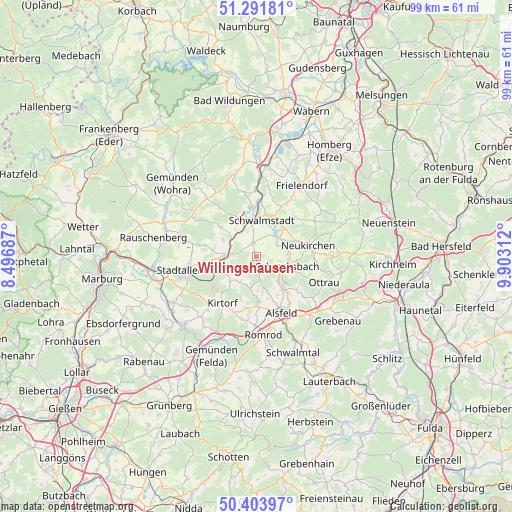
Willingshausen GPS coordinates[2]
50° 51' 0" North, 9° 12' 0" East
| Map corner | latitude | longitude |
|---|---|---|
| Upper-left | 51.29181°, | 8.49687° |
| Center: | 50.85°, | 9.2° |
| Lower-right: | 50.40397°, | 9.90312° |
| Map W x H: | 98.7×98.7 km | = 61.3×61.3mi |
| max Lat: | 55.01917° ⇑45% North |
| Willingshausen: | 50.85° |
| min Lat: | ⇓55% South 47.40724° |
| min Long | Willingshausen | max Long |
| 5.92978° | 9.2° | 14.98853° |
| W 37.6%⇐ | ⇒62.4% E |
Elevation
Elevation of Willingshausen is 230 m = 755 ft, and this is 19.1 m = 63 ft below average elevation for this country.
| Max E: |
1256 m = 4121 ft | 49.4% |
| Avg. | 249.1 m = 817 ft | |
| Willingshausen | 230 m = 755 ft | |
Min E: |
-5 m = -16 ft | 50.6% |
See also: Germany elevation on elevation.city.
Geographical zone
Willingshausen is located in North temperate zone (between Tropic of Cancer and the Arctic Circle). Distance of this North polar circle is 1747.2 km =1085.7 mi to North.| Distance of | km | miles | from Willingshausen |
|---|---|---|---|
| North Pole | 4353.1 | 2704.9 | to North |
| Arctic Circle | 1747.2 | 1085.7 | to North |
| Tropic Cancer | 3048.1 | 1894 | to South |
| Equator | 5654 | 3513.2 | to South |


Nearby cities:
15 places around Willingshausen: (largest is in red/bold)
• Alsfeld
12 km =7.5 mi,  155°
155°
• Frielendorf
15.9 km =9.9 mi,  32°
32°
• Gilserberg
14.5 km =9 mi,  319°
319°
• Kirtorf
11.2 km =7 mi,  217°
217°
• Neuental
16.7 km =10.4 mi,  4°
4°
• Neukirchen
10.5 km =6.5 mi,  78°
78°
• Neustadt (Hessen)
5.8 km =3.6 mi,  270°
270°
• Niederklein
15.6 km =9.7 mi,  246°
246°
• Ottrau
13.9 km =8.6 mi,  110°
110°
• Riebelsdorf
8.2 km =5.1 mi,  67°
67°
• Romrod
15.3 km =9.5 mi,  174°
174°
• Schrecksbach
6.1 km =3.8 mi, 107°
• Schwalmstadt
9.3 km =5.8 mi,  7°
7°
• Seigertshausen
13 km =8.1 mi,  58°
58°
• Stadtallendorf
13.5 km =8.4 mi,  256°
256°
Sources, notices
• [Note1] Compared only with cities in Germany existing in our database
• [Src1] Map data: © OpenStreetMap contributors (CC-BY-SA)
• [Src2] Other city data from geonames.org with taken over terms of usage.
• [Src3] Geographical zone / Annual Mean Temperature by Robert A. Rohde @ Wikipedia
