Gilserberg geodata
Gilserberg (Hesse) is a seat of a fourth-order administrative division; located in Germany in Europe/Berlin (GMT+2) time zone. With population of 3,470 people, there are 3638 cities with bigger population in this country. Compared to other cities in Germany, 57.1% of cities are located further ↓South; 64.5% of cities are located further →East and 68.4% of cities have lower elevation than Gilserberg. Note1
Administrative division(s):
- Level 1: Hesse
- Level 2: Regierungsbezirk Kassel
- Level 3: Schwalm-Eder-Kreis
- Level 4: Gilserberg


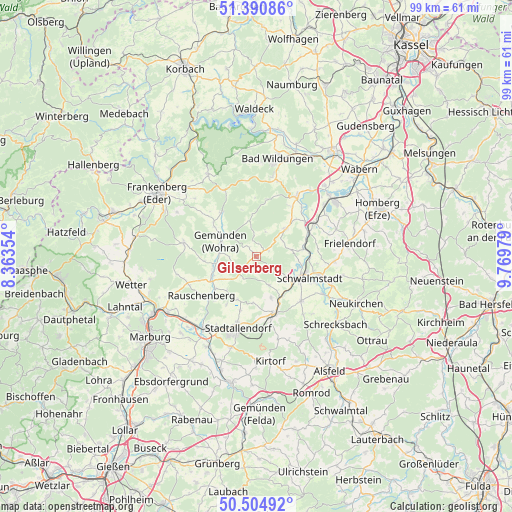
Gilserberg GPS coordinates[2]
50° 57' 0" North, 9° 4' 0.012" East
| Map corner | latitude | longitude |
|---|---|---|
| Upper-left | 51.39086°, | 8.36354° |
| Center: | 50.95°, | 9.06667° |
| Lower-right: | 50.50492°, | 9.76979° |
| Map W x H: | 98.5×98.5 km | = 61.2×61.2mi |
| max Lat: | 55.01917° ⇑42.9% North |
| Gilserberg: | 50.95° |
| min Lat: | ⇓57.1% South 47.40724° |
| min Long | Gilserberg | max Long |
| 5.92978° | 9.06667° | 14.98853° |
| W 35.5%⇐ | ⇒64.5% E |
Elevation
Elevation of Gilserberg is 346 m = 1135 ft, and this is 96.9 m = 318 ft above average elevation for this country.
| Max E: |
1256 m = 4121 ft | 31.6% |
| Gilserberg | 346 m 1135 ft | |
| Avg. | 249.1 m = 817 ft | |
Min E: |
-5 m = -16 ft | 68.4% |
See also: Germany elevation on elevation.city.
Geographical zone
Gilserberg is located in North temperate zone (between Tropic of Cancer and the Arctic Circle). Distance of this North polar circle is 1736.1 km =1078.8 mi to North.| Distance of | km | miles | from Gilserberg |
|---|---|---|---|
| North Pole | 4342 | 2698 | to North |
| Arctic Circle | 1736.1 | 1078.8 | to North |
| Tropic Cancer | 3059.2 | 1900.9 | to South |
| Equator | 5665.1 | 3520.1 | to South |


Nearby cities:
15 places around Gilserberg: (largest is in red/bold)
• Frankenau
18.4 km =11.4 mi,  329°
329°
• Frielendorf
18.1 km =11.2 mi,  82°
82°
• Gemünden an der Wohra
7.3 km =4.5 mi,  291°
291°
• Haina
10.8 km =6.7 mi,  323°
323°
• Jesberg
8.1 km =5 mi,  46°
46°
• Kirchhain
16.8 km =10.4 mi,  215°
215°
• Neuental
11.9 km =7.4 mi,  62°
62°
• Neustadt (Hessen)
11.7 km =7.3 mi,  162°
162°
• Niederklein
18 km =11.2 mi,  195°
195°
• Rauschenberg
12.8 km =8 mi,  234°
234°
• Reinhardshausen
18 km =11.2 mi,  1°
1°
• Rosenthal
14.2 km =8.8 mi,  280°
280°
• Schwalmstadt
10.7 km =6.6 mi,  100°
100°
• Stadtallendorf
14.7 km =9.1 mi,  194°
194°
• Willingshausen
14.5 km =9 mi,  139°
139°
Sources, notices
• [Note1] Compared only with cities in Germany existing in our database
• [Src1] Map data: © OpenStreetMap contributors (CC-BY-SA)
• [Src2] Other city data from geonames.org with taken over terms of usage.
• [Src3] Geographical zone / Annual Mean Temperature by Robert A. Rohde @ Wikipedia
