Kirtorf geodata
Kirtorf (Hesse) is a populated place; located in Germany in Europe/Berlin (GMT+2) time zone. With population of 3,649 people, there are 3509 cities with bigger population in this country. Compared to other cities in Germany, 53.7% of cities are located further ↓South; 63.9% of cities are located further →East and 56% of cities have lower elevation than Kirtorf. Note1
Administrative division(s):
- Level 1: Hesse
- Level 2: Regierungsbezirk Gießen
- Level 3: Vogelsbergkreis
- Level 4: Kirtorf


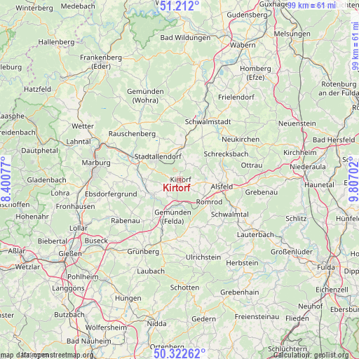
Kirtorf GPS coordinates[2]
50° 46' 9.912" North, 9° 6' 14.004" East
| Map corner | latitude | longitude |
|---|---|---|
| Upper-left | 51.212°, | 8.40077° |
| Center: | 50.76942°, | 9.10389° |
| Lower-right: | 50.32262°, | 9.80702° |
| Map W x H: | 98.9×98.9 km | = 61.5×61.5mi |
| max Lat: | 55.01917° ⇑46.3% North |
| Kirtorf: | 50.76942° |
| min Lat: | ⇓53.7% South 47.40724° |
| min Long | Kirtorf | max Long |
| 5.92978° | 9.10389° | 14.98853° |
| W 36.1%⇐ | ⇒63.9% E |
Elevation
Elevation of Kirtorf is 266 m = 873 ft, and this is 16.9 m = 55 ft above average elevation for this country.
| Max E: |
1256 m = 4121 ft | 44% |
| Kirtorf | 266 m 873 ft | |
| Avg. | 249.1 m = 817 ft | |
Min E: |
-5 m = -16 ft | 56% |
See also: Germany elevation on elevation.city.
Geographical zone
Kirtorf is located in North temperate zone (between Tropic of Cancer and the Arctic Circle). Distance of this North polar circle is 1756.1 km =1091.2 mi to North.| Distance of | km | miles | from Kirtorf |
|---|---|---|---|
| North Pole | 4362 | 2710.4 | to North |
| Arctic Circle | 1756.1 | 1091.2 | to North |
| Tropic Cancer | 3039.1 | 1888.4 | to South |
| Equator | 5645 | 3507.6 | to South |


Nearby cities:
15 places around Kirtorf: (largest is in red/bold)
• Alsfeld
11.9 km =7.4 mi,  99°
99°
• Amöneburg
13 km =8.1 mi,  283°
283°
• Ebsdorfergrund
18 km =11.2 mi,  254°
254°
• Homberg
8.7 km =5.4 mi,  240°
240°
• Höingen
14.1 km =8.8 mi, 246°
• Kirchhain
13.9 km =8.6 mi,  297°
297°
• Neustadt (Hessen)
9 km =5.6 mi,  5°
5°
• Niederklein
8 km =5 mi,  289°
289°
• Rauschenberg
18.2 km =11.3 mi,  314°
314°
• Riebelsdorf
18.7 km =11.6 mi,  49°
49°
• Romrod
10.3 km =6.4 mi,  127°
127°
• Schrecksbach
14.5 km =9 mi,  60°
60°
• Schwalmtal
12.4 km =7.7 mi,  140°
140°
• Stadtallendorf
8.7 km =5.4 mi, 312°
• Willingshausen
11.2 km =7 mi,  37°
37°
Sources, notices
• [Note1] Compared only with cities in Germany existing in our database
• [Src1] Map data: © OpenStreetMap contributors (CC-BY-SA)
• [Src2] Other city data from geonames.org with taken over terms of usage.
• [Src3] Geographical zone / Annual Mean Temperature by Robert A. Rohde @ Wikipedia
