Sömmerda geodata
Sömmerda (Thuringia) is a seat of a third-order administrative division; located in Germany in Europe/Berlin (GMT+2) time zone. With population of 20,853 people, there are 734 cities with bigger population in this country. Compared to other cities in Germany, 60.9% of cities are located further ↓South; 68.6% of cities are located further ←West and 61.8% of cities have higher elevation than Sömmerda. Note1


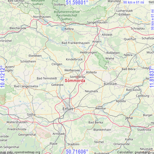
Sömmerda GPS coordinates[2]
51° 9' 32.904" North, 11° 6' 54.864" East
| Map corner | latitude | longitude |
|---|---|---|
| Upper-left | 51.59801°, | 10.41212° |
| Center: | 51.15914°, | 11.11524° |
| Lower-right: | 50.71606°, | 11.81837° |
| Map W x H: | 98.1×98.1 km | = 61×61mi |
| max Lat: | 55.01917° ⇑39.1% North |
| Sömmerda: | 51.15914° |
| min Lat: | ⇓60.9% South 47.40724° |
| min Long | Sömmerda | max Long |
| 5.92978° | 11.11524° | 14.98853° |
| W 68.6%⇐ | ⇒31.4% E |
Elevation
Elevation of Sömmerda is 140 m = 459 ft, and this is 109.1 m = 358 ft below average elevation for this country.
| Max E: |
1256 m = 4121 ft | 61.8% |
| Avg. | 249.1 m = 817 ft | |
| Sömmerda | 140 m = 459 ft | |
Min E: |
-5 m = -16 ft | 38.2% |
See also: Germany elevation on elevation.city.
Geographical zone
Sömmerda is located in North temperate zone (between Tropic of Cancer and the Arctic Circle). Distance of this North polar circle is 1712.8 km =1064.3 mi to North.| Distance of | km | miles | from Sömmerda |
|---|---|---|---|
| North Pole | 4318.7 | 2683.5 | to North |
| Arctic Circle | 1712.8 | 1064.3 | to North |
| Tropic Cancer | 3082.4 | 1915.3 | to South |
| Equator | 5688.4 | 3534.6 | to South |


Nearby cities:
15 places around Sömmerda: (largest is in red/bold)
• Alperstedt
8.9 km =5.5 mi,  213°
213°
• Eckstedt
10 km =6.2 mi,  167°
167°
• Griefstedt
7.9 km =4.9 mi,  7°
7°
• Großrudestedt
7.4 km =4.6 mi,  188°
188°
• Günstedt
7.4 km =4.6 mi,  340°
340°
• Haßleben
10 km =6.2 mi,  235°
235°
• Kölleda
9.6 km =6 mi,  70°
70°
• Markvippach
9.8 km =6.1 mi,  154°
154°
• Schloßvippach
6.4 km =4 mi,  160°
160°
• Sprötau
6.8 km =4.2 mi,  124°
124°
• Straußfurt
9.2 km =5.7 mi,  275°
275°
• Vogelsberg
9.8 km =6.1 mi,  106°
106°
• Weißensee
5.6 km =3.5 mi,  324°
324°
• Werningshausen
8.2 km =5.1 mi,  254°
254°
• Wundersleben
5.4 km =3.4 mi,  264°
264°
Sources, notices
• [Note1] Compared only with cities in Germany existing in our database
• [Src1] Map data: © OpenStreetMap contributors (CC-BY-SA)
• [Src2] Other city data from geonames.org with taken over terms of usage.
• [Src3] Geographical zone / Annual Mean Temperature by Robert A. Rohde @ Wikipedia
