Selters geodata
Selters (Hesse) is a populated place; located in Germany in Europe/Berlin (GMT+2) time zone. With population of 8,235 people, there are 1917 cities with bigger population in this country. Compared to other cities in Germany, 52.4% of cities are located further ↑North; 73% of cities are located further →East and 59.4% of cities have higher elevation than Selters. Note1
Administrative division(s):
- Level 1: Hesse
- Level 2: Regierungsbezirk Gießen
- Level 3: Landkreis Limburg-Weilburg
- Level 4: Löhnberg


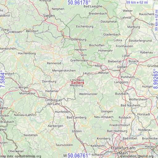
Selters GPS coordinates[2]
50° 31' 0.516" North, 8° 17' 22.308" East
| Map corner | latitude | longitude |
|---|---|---|
| Upper-left | 50.96178°, | 7.5864° |
| Center: | 50.51681°, | 8.28953° |
| Lower-right: | 50.06761°, | 8.99265° |
| Map W x H: | 99.4×99.4 km | = 61.8×61.8mi |
| max Lat: | 55.01917° ⇑52.4% North |
| Selters: | 50.51681° |
| min Lat: | ⇓47.6% South 47.40724° |
| min Long | Selters | max Long |
| 5.92978° | 8.28953° | 14.98853° |
| W 27%⇐ | ⇒73% E |
Elevation
Elevation of Selters is 157 m = 515 ft, and this is 92.1 m = 302 ft below average elevation for this country.
| Max E: |
1256 m = 4121 ft | 59.4% |
| Avg. | 249.1 m = 817 ft | |
| Selters | 157 m = 515 ft | |
Min E: |
-5 m = -16 ft | 40.6% |
See also: Germany elevation on elevation.city.
Geographical zone
Selters is located in North temperate zone (between Tropic of Cancer and the Arctic Circle). Distance of this North polar circle is 1784.2 km =1108.7 mi to North.| Distance of | km | miles | from Selters |
|---|---|---|---|
| North Pole | 4390.1 | 2727.9 | to North |
| Arctic Circle | 1784.2 | 1108.7 | to North |
| Tropic Cancer | 3011 | 1870.9 | to South |
| Equator | 5616.9 | 3490.2 | to South |


Nearby cities:
15 places around Selters: (largest is in red/bold)
• Albshausen
10.9 km =6.8 mi,  73°
73°
• Braunfels
7 km =4.3 mi,  91°
91°
• Burgsolms
8.6 km =5.3 mi, 70°
• Ehringshausen
11.4 km =7.1 mi,  35°
35°
• Greifenstein
11.1 km =6.9 mi,  3°
3°
• Leun
6.2 km =3.9 mi,  51°
51°
• Löhnberg
1.3 km =0.8 mi,  251°
251°
• Mengerskirchen
10.8 km =6.7 mi,  298°
298°
• Merenberg
7 km =4.3 mi,  261°
261°
• Niederbiel
8.8 km =5.5 mi,  61°
61°
• Oberbiel
10.6 km =6.6 mi, 67°
• Solms
8.6 km =5.3 mi,  75°
75°
• Weilburg
4.1 km =2.5 mi,  207°
207°
• Weilmünster
11.3 km =7 mi,  146°
146°
• Weinbach
8.7 km =5.4 mi,  179°
179°
Sources, notices
• [Note1] Compared only with cities in Germany existing in our database
• [Src1] Map data: © OpenStreetMap contributors (CC-BY-SA)
• [Src2] Other city data from geonames.org with taken over terms of usage.
• [Src3] Geographical zone / Annual Mean Temperature by Robert A. Rohde @ Wikipedia
