Greifenstein geodata
Greifenstein (Hesse) is a seat of a fourth-order administrative division; located in Germany in Europe/Berlin (GMT+2) time zone. With population of 7,507 people, there are 2070 cities with bigger population in this country. Compared to other cities in Germany, 50.2% of cities are located further ↑North; 72.9% of cities are located further →East and 69% of cities have lower elevation than Greifenstein. Note1
Administrative division(s):
- Level 1: Hesse
- Level 2: Regierungsbezirk Gießen
- Level 3: Lahn-Dill-Kreis
- Level 4: Greifenstein


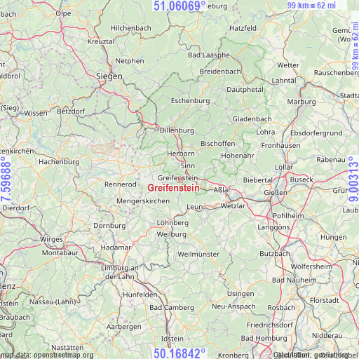
Greifenstein GPS coordinates[2]
50° 37' 0.012" North, 8° 18' 0" East
| Map corner | latitude | longitude |
|---|---|---|
| Upper-left | 51.06069°, | 7.59688° |
| Center: | 50.61667°, | 8.3° |
| Lower-right: | 50.16842°, | 9.00313° |
| Map W x H: | 99.2×99.2 km | = 61.6×61.6mi |
| max Lat: | 55.01917° ⇑50.2% North |
| Greifenstein: | 50.61667° |
| min Lat: | ⇓49.8% South 47.40724° |
| min Long | Greifenstein | max Long |
| 5.92978° | 8.3° | 14.98853° |
| W 27.1%⇐ | ⇒72.9% E |
Elevation
Elevation of Greifenstein is 351 m = 1152 ft, and this is 101.9 m = 334 ft above average elevation for this country.
| Max E: |
1256 m = 4121 ft | 31% |
| Greifenstein | 351 m 1152 ft | |
| Avg. | 249.1 m = 817 ft | |
Min E: |
-5 m = -16 ft | 69% |
See also: Germany elevation on elevation.city.
Geographical zone
Greifenstein is located in North temperate zone (between Tropic of Cancer and the Arctic Circle). Distance of this North polar circle is 1773.1 km =1101.8 mi to North.| Distance of | km | miles | from Greifenstein |
|---|---|---|---|
| North Pole | 4379 | 2721 | to North |
| Arctic Circle | 1773.1 | 1101.8 | to North |
| Tropic Cancer | 3022.1 | 1877.8 | to South |
| Equator | 5628 | 3497.1 | to South |


Nearby cities:
15 places around Greifenstein: (largest is in red/bold)
• Aßlar
11.8 km =7.3 mi,  103°
103°
• Breitscheid
10.8 km =6.7 mi,  314°
314°
• Burgsolms
11.1 km =6.9 mi,  138°
138°
• Driedorf
8.4 km =5.2 mi,  282°
282°
• Ehringshausen
6.2 km =3.9 mi,  107°
107°
• Herborn
7.2 km =4.5 mi,  2°
2°
• Leun
8.4 km =5.2 mi,  150°
150°
• Löhnberg
11.7 km =7.3 mi,  189°
189°
• Merkenbach
4.4 km =2.7 mi,  355°
355°
• Mittenaar
11 km =6.8 mi,  32°
32°
• Niederbiel
9.8 km =6.1 mi,  134°
134°
• Oberbiel
11.5 km =7.1 mi, 127°
• Selters
11.1 km =6.9 mi,  183°
183°
• Sinn
4.4 km =2.7 mi, 32°
• Solms
11.7 km =7.3 mi, 139°
Sources, notices
• [Note1] Compared only with cities in Germany existing in our database
• [Src1] Map data: © OpenStreetMap contributors (CC-BY-SA)
• [Src2] Other city data from geonames.org with taken over terms of usage.
• [Src3] Geographical zone / Annual Mean Temperature by Robert A. Rohde @ Wikipedia
