Ehringshausen geodata
Ehringshausen (Hesse) is a seat of a fourth-order administrative division; located in Germany in Europe/Berlin (GMT+2) time zone. With population of 9,505 people, there are 1703 cities with bigger population in this country. Compared to other cities in Germany, 50.6% of cities are located further ↑North; 72.1% of cities are located further →East and 57% of cities have higher elevation than Ehringshausen. Note1
Administrative division(s):
- Level 1: Hesse
- Level 2: Regierungsbezirk Gießen
- Level 3: Lahn-Dill-Kreis
- Level 4: Ehringshausen


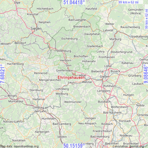
Ehringshausen GPS coordinates[2]
50° 36' 0" North, 8° 22' 59.988" East
| Map corner | latitude | longitude |
|---|---|---|
| Upper-left | 51.04418°, | 7.68021° |
| Center: | 50.6°, | 8.38333° |
| Lower-right: | 50.15159°, | 9.08646° |
| Map W x H: | 99.2×99.2 km | = 61.6×61.6mi |
| max Lat: | 55.01917° ⇑50.6% North |
| Ehringshausen: | 50.6° |
| min Lat: | ⇓49.4% South 47.40724° |
| min Long | Ehringshausen | max Long |
| 5.92978° | 8.38333° | 14.98853° |
| W 27.9%⇐ | ⇒72.1% E |
Elevation
Elevation of Ehringshausen is 175 m = 574 ft, and this is 74.1 m = 243 ft below average elevation for this country.
| Max E: |
1256 m = 4121 ft | 57% |
| Avg. | 249.1 m = 817 ft | |
| Ehringshausen | 175 m = 574 ft | |
Min E: |
-5 m = -16 ft | 43% |
See also: Germany elevation on elevation.city.
Geographical zone
Ehringshausen is located in North temperate zone (between Tropic of Cancer and the Arctic Circle). Distance of this North polar circle is 1775 km =1102.9 mi to North.| Distance of | km | miles | from Ehringshausen |
|---|---|---|---|
| North Pole | 4380.9 | 2722.2 | to North |
| Arctic Circle | 1775 | 1102.9 | to North |
| Tropic Cancer | 3020.3 | 1876.7 | to South |
| Equator | 5626.2 | 3496 | to South |


Nearby cities:
15 places around Ehringshausen: (largest is in red/bold)
• Albshausen
7.3 km =4.5 mi,  148°
148°
• Aßlar
5.7 km =3.5 mi,  99°
99°
• Braunfels
9.4 km =5.8 mi,  177°
177°
• Burgsolms
6.6 km =4.1 mi,  167°
167°
• Greifenstein
6.2 km =3.9 mi,  287°
287°
• Herborn
10.6 km =6.6 mi,  328°
328°
• Laufdorf
10.8 km =6.7 mi, 149°
• Leun
5.7 km =3.5 mi,  198°
198°
• Merkenbach
8.8 km =5.5 mi,  315°
315°
• Mittenaar
11.1 km =6.9 mi,  0°
0°
• Niederbiel
5.1 km =3.2 mi, 167°
• Oberbiel
6.1 km =3.8 mi, 148°
• Sinn
6.6 km =4.1 mi, 327°
• Solms
7.3 km =4.5 mi, 166°
• Wetzlar
9.6 km =6 mi,  116°
116°
Sources, notices
• [Note1] Compared only with cities in Germany existing in our database
• [Src1] Map data: © OpenStreetMap contributors (CC-BY-SA)
• [Src2] Other city data from geonames.org with taken over terms of usage.
• [Src3] Geographical zone / Annual Mean Temperature by Robert A. Rohde @ Wikipedia
