Weinbach geodata
Weinbach (Hesse) is a seat of a fourth-order administrative division; located in Germany in Europe/Berlin (GMT+2) time zone. With population of 4,763 people, there are 2916 cities with bigger population in this country. Compared to other cities in Germany, 53.9% of cities are located further ↑North; 73% of cities are located further →East and 56.5% of cities have higher elevation than Weinbach. Note1
Administrative division(s):
- Level 1: Hesse
- Level 2: Regierungsbezirk Gießen
- Level 3: Landkreis Limburg-Weilburg
- Level 4: Weinbach


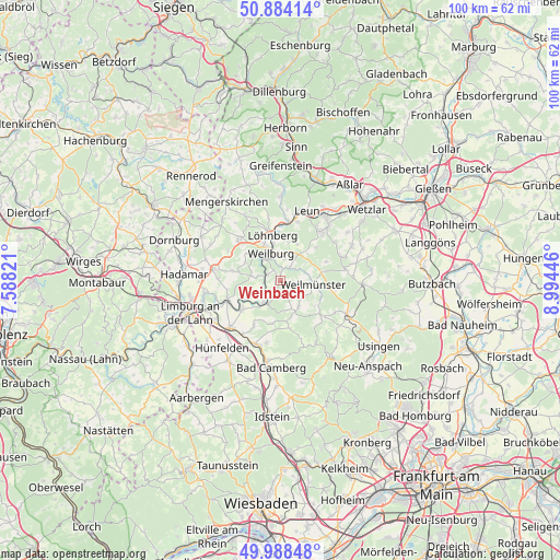
Weinbach GPS coordinates[2]
50° 26' 18.348" North, 8° 17' 28.788" East
| Map corner | latitude | longitude |
|---|---|---|
| Upper-left | 50.88414°, | 7.58821° |
| Center: | 50.43843°, | 8.29133° |
| Lower-right: | 49.98848°, | 8.99446° |
| Map W x H: | 99.6×99.6 km | = 61.9×61.9mi |
| max Lat: | 55.01917° ⇑53.9% North |
| Weinbach: | 50.43843° |
| min Lat: | ⇓46.1% South 47.40724° |
| min Long | Weinbach | max Long |
| 5.92978° | 8.29133° | 14.98853° |
| W 27%⇐ | ⇒73% E |
Elevation
Elevation of Weinbach is 178 m = 584 ft, and this is 71.1 m = 233 ft below average elevation for this country.
| Max E: |
1256 m = 4121 ft | 56.5% |
| Avg. | 249.1 m = 817 ft | |
| Weinbach | 178 m = 584 ft | |
Min E: |
-5 m = -16 ft | 43.5% |
See also: Germany elevation on elevation.city.
Geographical zone
Weinbach is located in North temperate zone (between Tropic of Cancer and the Arctic Circle). Distance of this North polar circle is 1792.9 km =1114.1 mi to North.| Distance of | km | miles | from Weinbach |
|---|---|---|---|
| North Pole | 4398.8 | 2733.3 | to North |
| Arctic Circle | 1792.9 | 1114.1 | to North |
| Tropic Cancer | 3002.3 | 1865.5 | to South |
| Equator | 5608.2 | 3484.8 | to South |


Nearby cities:
15 places around Weinbach: (largest is in red/bold)
• Braunfels
11 km =6.8 mi,  38°
38°
• Burgsolms
14 km =8.7 mi,  34°
34°
• Dehrn
13.8 km =8.6 mi,  261°
261°
• Grävenwiesbach
12.9 km =8 mi,  114°
114°
• Leun
13.4 km =8.3 mi,  20°
20°
• Löhnberg
8.4 km =5.2 mi,  350°
350°
• Merenberg
10.4 km =6.5 mi,  317°
317°
• Runkel
10.3 km =6.4 mi,  249°
249°
• Schwalbach
14.2 km =8.8 mi,  62°
62°
• Selters
8.7 km =5.4 mi,  359°
359°
• Solms
13.6 km =8.5 mi, 36°
• Steeden
11.9 km =7.4 mi, 257°
• Villmar
8.6 km =5.3 mi,  233°
233°
• Weilburg
5.5 km =3.4 mi,  338°
338°
• Weilmünster
6.1 km =3.8 mi,  97°
97°
Sources, notices
• [Note1] Compared only with cities in Germany existing in our database
• [Src1] Map data: © OpenStreetMap contributors (CC-BY-SA)
• [Src2] Other city data from geonames.org with taken over terms of usage.
• [Src3] Geographical zone / Annual Mean Temperature by Robert A. Rohde @ Wikipedia
