Segnitz geodata
Segnitz (Bavaria) is a seat of a fourth-order administrative division; located in Germany in Europe/Berlin (GMT+2) time zone. With population of 846 people, there are 7722 cities with bigger population in this country. Compared to other cities in Germany, 71.9% of cities are located further ↑North; 52.4% of cities are located further ←West and 55.5% of cities have higher elevation than Segnitz. Note1
Administrative division(s):
- Level 1: Bavaria
- Level 2: Regierungsbezirk Unterfranken
- Level 3: Landkreis Kitzingen
- Level 4: Segnitz


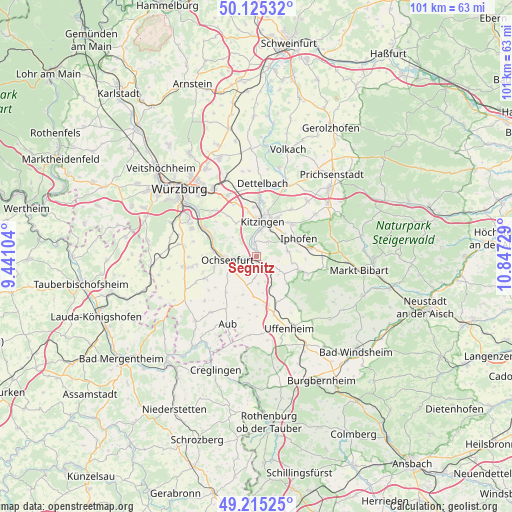
Segnitz GPS coordinates[2]
49° 40' 20.676" North, 10° 8' 38.976" East
| Map corner | latitude | longitude |
|---|---|---|
| Upper-left | 50.12532°, | 9.44104° |
| Center: | 49.67241°, | 10.14416° |
| Lower-right: | 49.21525°, | 10.84729° |
| Map W x H: | 101.2×101.2 km | = 62.9×62.9mi |
| max Lat: | 55.01917° ⇑71.9% North |
| Segnitz: | 49.67241° |
| min Lat: | ⇓28.1% South 47.40724° |
| min Long | Segnitz | max Long |
| 5.92978° | 10.14416° | 14.98853° |
| W 52.4%⇐ | ⇒47.6% E |
Elevation
Elevation of Segnitz is 185 m = 607 ft, and this is 64.1 m = 210 ft below average elevation for this country.
| Max E: |
1256 m = 4121 ft | 55.5% |
| Avg. | 249.1 m = 817 ft | |
| Segnitz | 185 m = 607 ft | |
Min E: |
-5 m = -16 ft | 44.5% |
See also: Germany elevation on elevation.city.
Geographical zone
Segnitz is located in North temperate zone (between Tropic of Cancer and the Arctic Circle). Distance of this North polar circle is 1878.1 km =1167 mi to North.| Distance of | km | miles | from Segnitz |
|---|---|---|---|
| North Pole | 4484 | 2786.2 | to North |
| Arctic Circle | 1878.1 | 1167 | to North |
| Tropic Cancer | 2917.1 | 1812.6 | to South |
| Equator | 5523.1 | 3431.9 | to South |


Nearby cities:
15 places around Segnitz: (largest is in red/bold)
• Frickenhausen
3.7 km =2.3 mi,  267°
267°
• Iphofen
9 km =5.6 mi,  68°
68°
• Kitzingen
7.5 km =4.7 mi,  3°
3°
• Mainbernheim
6.7 km =4.2 mi,  53°
53°
• Marktbreit
0.8 km =0.5 mi,  159°
159°
• Marktsteft
2.7 km =1.7 mi,  347°
347°
• Martinsheim
5.4 km =3.4 mi,  176°
176°
• Oberickelsheim
8.1 km =5 mi,  185°
185°
• Obernbreit
2.1 km =1.3 mi,  136°
136°
• Ochsenfurt
6 km =3.7 mi,  261°
261°
• Rödelsee
9.5 km =5.9 mi, 48°
• Seinsheim
6.5 km =4 mi,  122°
122°
• Sommerhausen
9.2 km =5.7 mi,  292°
292°
• Sulzfeld am Main
3.9 km =2.4 mi, 347°
• Willanzheim
6.4 km =4 mi,  82°
82°
Sources, notices
• [Note1] Compared only with cities in Germany existing in our database
• [Src1] Map data: © OpenStreetMap contributors (CC-BY-SA)
• [Src2] Other city data from geonames.org with taken over terms of usage.
• [Src3] Geographical zone / Annual Mean Temperature by Robert A. Rohde @ Wikipedia
