Mainbernheim geodata
Mainbernheim (Bavaria) is a populated place; located in Germany in Europe/Berlin (GMT+2) time zone. With population of 2,294 people, there are 4683 cities with bigger population in this country. Compared to other cities in Germany, 71.2% of cities are located further ↑North; 53.7% of cities are located further ←West and 50.5% of cities have higher elevation than Mainbernheim. Note1
Administrative division(s):
- Level 1: Bavaria
- Level 2: Regierungsbezirk Unterfranken
- Level 3: Landkreis Kitzingen
- Level 4: Mainbernheim


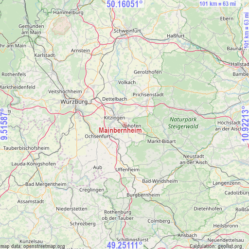
Mainbernheim GPS coordinates[2]
49° 42' 28.584" North, 10° 13' 8.4" East
| Map corner | latitude | longitude |
|---|---|---|
| Upper-left | 50.16051°, | 9.51587° |
| Center: | 49.70794°, | 10.219° |
| Lower-right: | 49.25111°, | 10.92213° |
| Map W x H: | 101.1×101.1 km | = 62.8×62.8mi |
| max Lat: | 55.01917° ⇑71.2% North |
| Mainbernheim: | 49.70794° |
| min Lat: | ⇓28.8% South 47.40724° |
| min Long | Mainbernheim | max Long |
| 5.92978° | 10.219° | 14.98853° |
| W 53.7%⇐ | ⇒46.3% E |
Elevation
Elevation of Mainbernheim is 221 m = 725 ft, and this is 28.1 m = 92 ft below average elevation for this country.
| Max E: |
1256 m = 4121 ft | 50.5% |
| Avg. | 249.1 m = 817 ft | |
| Mainbernheim | 221 m = 725 ft | |
Min E: |
-5 m = -16 ft | 49.5% |
See also: Germany elevation on elevation.city.
Geographical zone
Mainbernheim is located in North temperate zone (between Tropic of Cancer and the Arctic Circle). Distance of this North polar circle is 1874.2 km =1164.6 mi to North.| Distance of | km | miles | from Mainbernheim |
|---|---|---|---|
| North Pole | 4480.1 | 2783.8 | to North |
| Arctic Circle | 1874.2 | 1164.6 | to North |
| Tropic Cancer | 2921.1 | 1815.1 | to South |
| Equator | 5527 | 3434.3 | to South |


Nearby cities:
15 places around Mainbernheim: (largest is in red/bold)
• Albertshofen
7.5 km =4.7 mi,  330°
330°
• Buchbrunn
8.3 km =5.2 mi,  314°
314°
• Großlangheim
5.6 km =3.5 mi,  16°
16°
• Iphofen
3 km =1.9 mi,  101°
101°
• Kitzingen
6 km =3.7 mi, 305°
• Markt Einersheim
5.7 km =3.5 mi,  114°
114°
• Marktbreit
7 km =4.3 mi,  227°
227°
• Marktsteft
6.1 km =3.8 mi,  257°
257°
• Obernbreit
6.8 km =4.2 mi,  215°
215°
• Rödelsee
2.9 km =1.8 mi,  37°
37°
• Segnitz
6.7 km =4.2 mi, 233°
• Seinsheim
7.5 km =4.7 mi,  179°
179°
• Sulzfeld am Main
6.2 km =3.9 mi,  268°
268°
• Wiesenbronn
7.5 km =4.7 mi,  51°
51°
• Willanzheim
3.2 km =2 mi,  162°
162°
Sources, notices
• [Note1] Compared only with cities in Germany existing in our database
• [Src1] Map data: © OpenStreetMap contributors (CC-BY-SA)
• [Src2] Other city data from geonames.org with taken over terms of usage.
• [Src3] Geographical zone / Annual Mean Temperature by Robert A. Rohde @ Wikipedia
