Rödelsee geodata
Rödelsee (Bavaria) is a seat of a fourth-order administrative division; located in Germany in Europe/Berlin (GMT+2) time zone. With population of 1,536 people, there are 5804 cities with bigger population in this country. Compared to other cities in Germany, 70.7% of cities are located further ↑North; 54.2% of cities are located further ←West and 52.2% of cities have lower elevation than Rödelsee. Note1
Administrative division(s):
- Level 1: Bavaria
- Level 2: Regierungsbezirk Unterfranken
- Level 3: Landkreis Kitzingen
- Level 4: Rödelsee


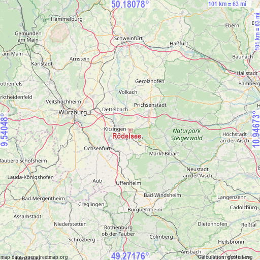
Rödelsee GPS coordinates[2]
49° 43' 42.24" North, 10° 14' 36.96" East
| Map corner | latitude | longitude |
|---|---|---|
| Upper-left | 50.18078°, | 9.54048° |
| Center: | 49.7284°, | 10.2436° |
| Lower-right: | 49.27176°, | 10.94673° |
| Map W x H: | 101.1×101.1 km | = 62.8×62.8mi |
| max Lat: | 55.01917° ⇑70.7% North |
| Rödelsee: | 49.7284° |
| min Lat: | ⇓29.3% South 47.40724° |
| min Long | Rödelsee | max Long |
| 5.92978° | 10.2436° | 14.98853° |
| W 54.2%⇐ | ⇒45.8% E |
Elevation
Elevation of Rödelsee is 241 m = 791 ft, and this is 8.1 m = 27 ft below average elevation for this country.
| Max E: |
1256 m = 4121 ft | 47.8% |
| Avg. | 249.1 m = 817 ft | |
| Rödelsee | 241 m = 791 ft | |
Min E: |
-5 m = -16 ft | 52.2% |
See also: Germany elevation on elevation.city.
Geographical zone
Rödelsee is located in North temperate zone (between Tropic of Cancer and the Arctic Circle). Distance of this North polar circle is 1871.9 km =1163.1 mi to North.| Distance of | km | miles | from Rödelsee |
|---|---|---|---|
| North Pole | 4477.8 | 2782.4 | to North |
| Arctic Circle | 1871.9 | 1163.1 | to North |
| Tropic Cancer | 2923.4 | 1816.5 | to South |
| Equator | 5529.3 | 3435.7 | to South |


Nearby cities:
15 places around Rödelsee: (largest is in red/bold)
• Albertshofen
7 km =4.3 mi,  307°
307°
• Buchbrunn
8.4 km =5.2 mi,  294°
294°
• Castell
7.8 km =4.8 mi,  79°
79°
• Großlangheim
3.1 km =1.9 mi,  356°
356°
• Iphofen
3.1 km =1.9 mi,  157°
157°
• Kitzingen
6.8 km =4.2 mi,  280°
280°
• Kleinlangheim
5.6 km =3.5 mi,  31°
31°
• Mainbernheim
2.9 km =1.8 mi,  217°
217°
• Mainstockheim
8.4 km =5.2 mi,  304°
304°
• Markt Einersheim
5.8 km =3.6 mi,  143°
143°
• Marktsteft
8.5 km =5.3 mi,  245°
245°
• Rüdenhausen
8 km =5 mi,  59°
59°
• Sulzfeld am Main
8.3 km =5.2 mi, 253°
• Wiesenbronn
4.7 km =2.9 mi, 59°
• Willanzheim
5.4 km =3.4 mi,  188°
188°
Sources, notices
• [Note1] Compared only with cities in Germany existing in our database
• [Src1] Map data: © OpenStreetMap contributors (CC-BY-SA)
• [Src2] Other city data from geonames.org with taken over terms of usage.
• [Src3] Geographical zone / Annual Mean Temperature by Robert A. Rohde @ Wikipedia
