Kitzingen geodata
Kitzingen (Bavaria) is a seat of a third-order administrative division; located in Germany in Europe/Berlin (GMT+2) time zone. With population of 21,387 people, there are 709 cities with bigger population in this country. Compared to other cities in Germany, 70.4% of cities are located further ↑North; 52.5% of cities are located further ←West and 53.4% of cities have higher elevation than Kitzingen. Note1
Administrative division(s):
- Level 1: Bavaria
- Level 2: Regierungsbezirk Unterfranken
- Level 3: Landkreis Kitzingen
- Level 4: Kitzingen


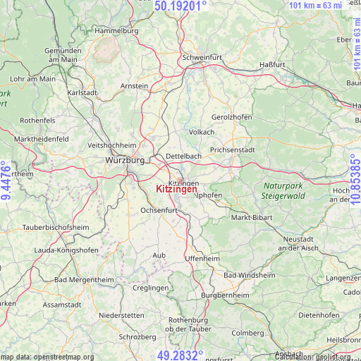
Kitzingen GPS coordinates[2]
49° 44' 23.028" North, 10° 9' 2.592" East
| Map corner | latitude | longitude |
|---|---|---|
| Upper-left | 50.19201°, | 9.4476° |
| Center: | 49.73973°, | 10.15072° |
| Lower-right: | 49.2832°, | 10.85385° |
| Map W x H: | 101.1×101 km | = 62.8×62.8mi |
| max Lat: | 55.01917° ⇑70.4% North |
| Kitzingen: | 49.73973° |
| min Lat: | ⇓29.6% South 47.40724° |
| min Long | Kitzingen | max Long |
| 5.92978° | 10.15072° | 14.98853° |
| W 52.5%⇐ | ⇒47.5% E |
Elevation
Elevation of Kitzingen is 201 m = 659 ft, and this is 48.1 m = 158 ft below average elevation for this country.
| Max E: |
1256 m = 4121 ft | 53.4% |
| Avg. | 249.1 m = 817 ft | |
| Kitzingen | 201 m = 659 ft | |
Min E: |
-5 m = -16 ft | 46.6% |
See also: Germany elevation on elevation.city.
Geographical zone
Kitzingen is located in North temperate zone (between Tropic of Cancer and the Arctic Circle). Distance of this North polar circle is 1870.6 km =1162.3 mi to North.| Distance of | km | miles | from Kitzingen |
|---|---|---|---|
| North Pole | 4476.5 | 2781.6 | to North |
| Arctic Circle | 1870.6 | 1162.3 | to North |
| Tropic Cancer | 2924.6 | 1817.3 | to South |
| Equator | 5530.5 | 3436.5 | to South |


Nearby cities:
15 places around Kitzingen: (largest is in red/bold)
• Albertshofen
3.2 km =2 mi,  20°
20°
• Biebelried
5.7 km =3.5 mi,  301°
301°
• Buchbrunn
2.4 km =1.5 mi,  335°
335°
• Dettelbach
7.1 km =4.4 mi,  8°
8°
• Frickenhausen
8.7 km =5.4 mi,  208°
208°
• Großlangheim
6.7 km =4.2 mi,  74°
74°
• Iphofen
8.9 km =5.5 mi,  117°
117°
• Mainbernheim
6 km =3.7 mi,  125°
125°
• Mainstockheim
3.5 km =2.2 mi,  356°
356°
• Marktbreit
8.3 km =5.2 mi,  181°
181°
• Marktsteft
5 km =3.1 mi,  192°
192°
• Rödelsee
6.8 km =4.2 mi,  100°
100°
• Segnitz
7.5 km =4.7 mi, 183°
• Sulzfeld am Main
3.9 km =2.4 mi,  199°
199°
• Theilheim
8.8 km =5.5 mi,  280°
280°
Sources, notices
• [Note1] Compared only with cities in Germany existing in our database
• [Src1] Map data: © OpenStreetMap contributors (CC-BY-SA)
• [Src2] Other city data from geonames.org with taken over terms of usage.
• [Src3] Geographical zone / Annual Mean Temperature by Robert A. Rohde @ Wikipedia
