Andechs geodata
Andechs (Bavaria) is a seat of a fourth-order administrative division; located in Germany in Europe/Berlin (GMT+2) time zone. With population of 3,181 people, there are 3844 cities with bigger population in this country. Compared to other cities in Germany, 95.8% of cities are located further ↑North; 69.7% of cities are located further ←West and 97.9% of cities have lower elevation than Andechs. Note1
Administrative division(s):
- Level 1: Bavaria
- Level 2: Upper Bavaria
- Level 3: Landkreis Starnberg
- Level 4: Andechs


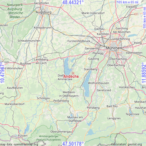
Andechs GPS coordinates[2]
47° 58' 28.704" North, 11° 10' 58.044" East
| Map corner | latitude | longitude |
|---|---|---|
| Upper-left | 48.44321°, | 10.47967° |
| Center: | 47.97464°, | 11.18279° |
| Lower-right: | 47.50178°, | 11.88592° |
| Map W x H: | 104.7×104.7 km | = 65.1×65.1mi |
| max Lat: | 55.01917° ⇑95.8% North |
| Andechs: | 47.97464° |
| min Lat: | ⇓4.2% South 47.40724° |
| min Long | Andechs | max Long |
| 5.92978° | 11.18279° | 14.98853° |
| W 69.7%⇐ | ⇒30.3% E |
Elevation
Elevation of Andechs is 703 m = 2306 ft, and this is 453.9 m = 1489 ft above average elevation for this country.
| Max E: |
1256 m = 4121 ft | 2.1% |
| Andechs | 703 m 2306 ft | |
| Avg. | 249.1 m = 817 ft | |
Min E: |
-5 m = -16 ft | 97.9% |
See also: Germany elevation on elevation.city.
Geographical zone
Andechs is located in North temperate zone (between Tropic of Cancer and the Arctic Circle). Distance of this North polar circle is 2066.9 km =1284.3 mi to North.| Distance of | km | miles | from Andechs |
|---|---|---|---|
| North Pole | 4672.8 | 2903.5 | to North |
| Arctic Circle | 2066.9 | 1284.3 | to North |
| Tropic Cancer | 2728.4 | 1695.3 | to South |
| Equator | 5334.3 | 3314.6 | to South |


Nearby cities:
15 places around Andechs: (largest is in red/bold)
• Dießen am Ammersee
6.5 km =4 mi,  245°
245°
• Feldafing
8.8 km =5.5 mi,  111°
111°
• Herrsching am Ammersee
2.7 km =1.7 mi,  350°
350°
• Inning am Ammersee
11.5 km =7.1 mi, 348°
• Pähl
8.3 km =5.2 mi,  179°
179°
• Pöcking
8.8 km =5.5 mi,  95°
95°
• Raisting
8.9 km =5.5 mi,  223°
223°
• Schondorf am Ammersee
11 km =6.8 mi,  322°
322°
• Seefeld
7.1 km =4.4 mi,  19°
19°
• Starnberg
12.4 km =7.7 mi,  75°
75°
• Tutzing
10.3 km =6.4 mi,  134°
134°
• Utting am Ammersee
9.2 km =5.7 mi,  308°
308°
• Weßling
12.1 km =7.5 mi, 23°
• Wielenbach
11.3 km =7 mi,  188°
188°
• Wörthsee
11 km =6.8 mi,  7°
7°
In other languages:
- In France: Andechs, Abbaye d'Andechs
- In German: Kloster Andechs
- In Russian: Андекс
Sources, notices
• [Note1] Compared only with cities in Germany existing in our database
• [Src1] Map data: © OpenStreetMap contributors (CC-BY-SA)
• [Src2] Other city data from geonames.org with taken over terms of usage.
• [Src3] Geographical zone / Annual Mean Temperature by Robert A. Rohde @ Wikipedia
