Starnberg geodata
Starnberg (Bavaria) is a seat of a third-order administrative division; located in Germany in Europe/Berlin (GMT+2) time zone. With population of 23,086 people, there are 644 cities with bigger population in this country. Compared to other cities in Germany, 95.5% of cities are located further ↑North; 71.9% of cities are located further ←West and 94.7% of cities have lower elevation than Starnberg. Note1
Administrative division(s):
- Level 1: Bavaria
- Level 2: Upper Bavaria
- Level 3: Landkreis Starnberg
- Level 4: Starnberg


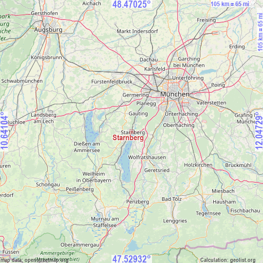
Starnberg GPS coordinates[2]
48° 0' 6.948" North, 11° 20' 38.976" East
| Map corner | latitude | longitude |
|---|---|---|
| Upper-left | 48.47025°, | 10.64104° |
| Center: | 48.00193°, | 11.34416° |
| Lower-right: | 47.52932°, | 12.04729° |
| Map W x H: | 104.6×104.6 km | = 65×65mi |
| max Lat: | 55.01917° ⇑95.5% North |
| Starnberg: | 48.00193° |
| min Lat: | ⇓4.5% South 47.40724° |
| min Long | Starnberg | max Long |
| 5.92978° | 11.34416° | 14.98853° |
| W 71.9%⇐ | ⇒28.1% E |
Elevation
Elevation of Starnberg is 592 m = 1942 ft, and this is 342.9 m = 1125 ft above average elevation for this country.
| Max E: |
1256 m = 4121 ft | 5.3% |
| Starnberg | 592 m 1942 ft | |
| Avg. | 249.1 m = 817 ft | |
Min E: |
-5 m = -16 ft | 94.7% |
See also: Germany elevation on elevation.city.
Geographical zone
Starnberg is located in North temperate zone (between Tropic of Cancer and the Arctic Circle). Distance of this North polar circle is 2063.9 km =1282.4 mi to North.| Distance of | km | miles | from Starnberg |
|---|---|---|---|
| North Pole | 4669.7 | 2901.6 | to North |
| Arctic Circle | 2063.9 | 1282.4 | to North |
| Tropic Cancer | 2731.4 | 1697.2 | to South |
| Equator | 5337.3 | 3316.4 | to South |


Nearby cities:
15 places around Starnberg: (largest is in red/bold)
• Andechs
12.4 km =7.7 mi,  255°
255°
• Baierbrunn
10.8 km =6.7 mi,  79°
79°
• Berg
3.9 km =2.4 mi,  168°
168°
• Feldafing
7.3 km =4.5 mi,  211°
211°
• Gauting
7.9 km =4.9 mi,  18°
18°
• Gilching
12.3 km =7.6 mi,  342°
342°
• Icking
8.8 km =5.5 mi,  131°
131°
• Krailling
11.7 km =7.3 mi, 20°
• Münsing
11.5 km =7.1 mi, 171°
• Pöcking
5.1 km =3.2 mi,  219°
219°
• Schäftlarn
8.4 km =5.2 mi,  98°
98°
• Seefeld
10.4 km =6.5 mi,  290°
290°
• Tutzing
11.3 km =7 mi,  204°
204°
• Weßling
10.8 km =6.7 mi,  318°
318°
• Wolfratshausen
11.5 km =7.1 mi,  149°
149°
Sources, notices
• [Note1] Compared only with cities in Germany existing in our database
• [Src1] Map data: © OpenStreetMap contributors (CC-BY-SA)
• [Src2] Other city data from geonames.org with taken over terms of usage.
• [Src3] Geographical zone / Annual Mean Temperature by Robert A. Rohde @ Wikipedia
