Feldafing geodata
Feldafing (Bavaria) is a seat of a fourth-order administrative division; located in Germany in Europe/Berlin (GMT+2) time zone. With population of 4,293 people, there are 3134 cities with bigger population in this country. Compared to other cities in Germany, 96.1% of cities are located further ↑North; 71.2% of cities are located further ←West and 97.2% of cities have lower elevation than Feldafing. Note1
Administrative division(s):
- Level 1: Bavaria
- Level 2: Upper Bavaria
- Level 3: Landkreis Starnberg
- Level 4: Feldafing


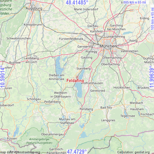
Feldafing GPS coordinates[2]
47° 56' 45.672" North, 11° 17' 35.736" East
| Map corner | latitude | longitude |
|---|---|---|
| Upper-left | 48.41485°, | 10.59014° |
| Center: | 47.94602°, | 11.29326° |
| Lower-right: | 47.4729°, | 11.99639° |
| Map W x H: | 104.7×104.7 km | = 65.1×65.1mi |
| max Lat: | 55.01917° ⇑96.1% North |
| Feldafing: | 47.94602° |
| min Lat: | ⇓3.9% South 47.40724° |
| min Long | Feldafing | max Long |
| 5.92978° | 11.29326° | 14.98853° |
| W 71.2%⇐ | ⇒28.8% E |
Elevation
Elevation of Feldafing is 669 m = 2195 ft, and this is 419.9 m = 1378 ft above average elevation for this country.
| Max E: |
1256 m = 4121 ft | 2.8% |
| Feldafing | 669 m 2195 ft | |
| Avg. | 249.1 m = 817 ft | |
Min E: |
-5 m = -16 ft | 97.2% |
See also: Germany elevation on elevation.city.
Geographical zone
Feldafing is located in North temperate zone (between Tropic of Cancer and the Arctic Circle). Distance of this North polar circle is 2070.1 km =1286.3 mi to North.| Distance of | km | miles | from Feldafing |
|---|---|---|---|
| North Pole | 4676 | 2905.5 | to North |
| Arctic Circle | 2070.1 | 1286.3 | to North |
| Tropic Cancer | 2725.2 | 1693.4 | to South |
| Equator | 5331.1 | 3312.6 | to South |


Nearby cities:
15 places around Feldafing: (largest is in red/bold)
• Andechs
8.8 km =5.5 mi,  291°
291°
• Berg
5.1 km =3.2 mi,  62°
62°
• Bernried
8.9 km =5.5 mi,  179°
179°
• Eurasburg
13.2 km =8.2 mi,  140°
140°
• Herrsching am Ammersee
10.5 km =6.5 mi,  304°
304°
• Icking
10.4 km =6.5 mi,  87°
87°
• Münsing
7.5 km =4.7 mi,  133°
133°
• Pähl
9.7 km =6 mi,  238°
238°
• Pöcking
2.4 km =1.5 mi,  12°
12°
• Schäftlarn
13.1 km =8.1 mi,  67°
67°
• Seefeld
11.5 km =7.1 mi,  329°
329°
• Starnberg
7.3 km =4.5 mi,  31°
31°
• Tutzing
4.2 km =2.6 mi,  193°
193°
• Wielenbach
12.8 km =8 mi,  231°
231°
• Wolfratshausen
10.3 km =6.4 mi,  111°
111°
Sources, notices
• [Note1] Compared only with cities in Germany existing in our database
• [Src1] Map data: © OpenStreetMap contributors (CC-BY-SA)
• [Src2] Other city data from geonames.org with taken over terms of usage.
• [Src3] Geographical zone / Annual Mean Temperature by Robert A. Rohde @ Wikipedia
