Oppin geodata
Oppin (Saxony-Anhalt) is a populated place; located in Germany in Europe/Berlin (GMT+2) time zone. With population of 1,563 people, there are 5755 cities with bigger population in this country. Compared to other cities in Germany, 66.9% of cities are located further ↓South; 82.2% of cities are located further ←West and 65.6% of cities have higher elevation than Oppin. Note1


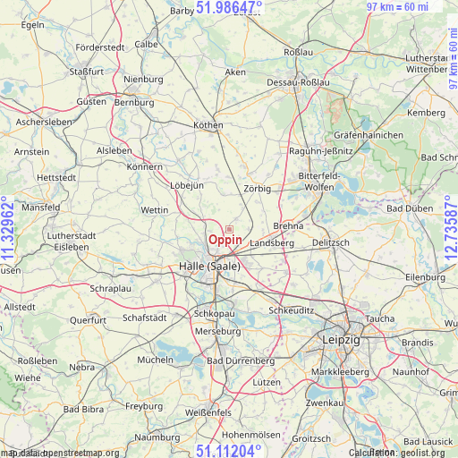
Oppin GPS coordinates[2]
51° 33' 4.896" North, 12° 1' 57.864" East
| Map corner | latitude | longitude |
|---|---|---|
| Upper-left | 51.98647°, | 11.32962° |
| Center: | 51.55136°, | 12.03274° |
| Lower-right: | 51.11204°, | 12.73587° |
| Map W x H: | 97.2×97.2 km | = 60.4×60.4mi |
| max Lat: | 55.01917° ⇑33.1% North |
| Oppin: | 51.55136° |
| min Lat: | ⇓66.9% South 47.40724° |
| min Long | Oppin | max Long |
| 5.92978° | 12.03274° | 14.98853° |
| W 82.2%⇐ | ⇒17.8% E |
Elevation
Elevation of Oppin is 117 m = 384 ft, and this is 132.1 m = 433 ft below average elevation for this country.
| Max E: |
1256 m = 4121 ft | 65.6% |
| Avg. | 249.1 m = 817 ft | |
| Oppin | 117 m = 384 ft | |
Min E: |
-5 m = -16 ft | 34.4% |
See also: Germany elevation on elevation.city.
Geographical zone
Oppin is located in North temperate zone (between Tropic of Cancer and the Arctic Circle). Distance of this North polar circle is 1669.2 km =1037.2 mi to North.| Distance of | km | miles | from Oppin |
|---|---|---|---|
| North Pole | 4275.1 | 2656.4 | to North |
| Arctic Circle | 1669.2 | 1037.2 | to North |
| Tropic Cancer | 3126.1 | 1942.5 | to South |
| Equator | 5732 | 3561.7 | to South |


Nearby cities:
15 places around Oppin: (largest is in red/bold)
• Brachstedt
2.5 km =1.6 mi,  30°
30°
• Braschwitz
3.6 km =2.2 mi,  150°
150°
• Gutenberg
4.2 km =2.6 mi,  263°
263°
• Hohenthurm
5.8 km =3.6 mi,  129°
129°
• Morl
7.7 km =4.8 mi,  271°
271°
• Niemberg
4 km =2.5 mi,  91°
91°
• Peißen
5.7 km =3.5 mi,  162°
162°
• Petersberg
7.4 km =4.6 mi,  312°
312°
• Schrenz
4.8 km =3 mi, 33°
• Schwerz
7.1 km =4.4 mi,  77°
77°
• Sennewitz
5.6 km =3.5 mi, 260°
• Spickendorf
6.9 km =4.3 mi, 90°
• Stumsdorf
7.5 km =4.7 mi,  16°
16°
• Teicha
5.5 km =3.4 mi,  278°
278°
• Wallwitz
7.9 km =4.9 mi,  294°
294°
Sources, notices
• [Note1] Compared only with cities in Germany existing in our database
• [Src1] Map data: © OpenStreetMap contributors (CC-BY-SA)
• [Src2] Other city data from geonames.org with taken over terms of usage.
• [Src3] Geographical zone / Annual Mean Temperature by Robert A. Rohde @ Wikipedia
