Schwallungen geodata
Schwallungen (Thuringia) is a seat of a fourth-order administrative division; located in Germany in Europe/Berlin (GMT+1) time zone. With population of 2,782 people, there are 4176 cities with bigger population in this country. Compared to other cities in Germany, 51.8% of cities are located further ↓South; 56.5% of cities are located further ←West and 57.3% of cities have lower elevation than Schwallungen. Note1
Administrative division(s):
- Level 1: Thuringia
- Level 3: Landkreis Schmalkalden-Meiningen
- Level 4: Schwallungen


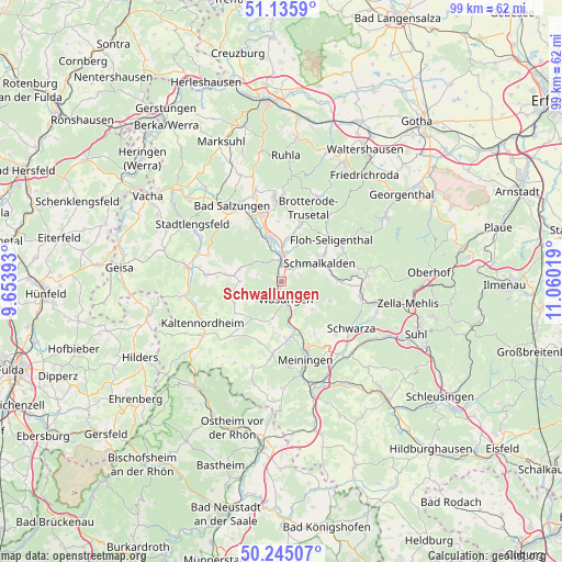
Schwallungen GPS coordinates[2]
50° 41' 33.36" North, 10° 21' 25.416" East
| Map corner | latitude | longitude |
|---|---|---|
| Upper-left | 51.1359°, | 9.65393° |
| Center: | 50.6926°, | 10.35706° |
| Lower-right: | 50.24507°, | 11.06019° |
| Map W x H: | 99.1×99.1 km | = 61.6×61.6mi |
| max Lat: | 55.01917° ⇑48.2% North |
| Schwallungen: | 50.6926° |
| min Lat: | ⇓51.8% South 47.40724° |
| min Long | Schwallungen | max Long |
| 5.92978° | 10.35706° | 14.98853° |
| W 56.5%⇐ | ⇒43.5% E |
Elevation
Elevation of Schwallungen is 274 m = 899 ft, and this is 24.9 m = 82 ft above average elevation for this country.
| Max E: |
1256 m = 4121 ft | 42.7% |
| Schwallungen | 274 m 899 ft | |
| Avg. | 249.1 m = 817 ft | |
Min E: |
-5 m = -16 ft | 57.3% |
See also: Germany elevation on elevation.city.
Geographical zone
Schwallungen is located in North temperate zone (between Tropic of Cancer and the Arctic Circle). Distance of this North polar circle is 1764.7 km =1096.5 mi to North.| Distance of | km | miles | from Schwallungen |
|---|---|---|---|
| North Pole | 4370.6 | 2715.8 | to North |
| Arctic Circle | 1764.7 | 1096.5 | to North |
| Tropic Cancer | 3030.6 | 1883.1 | to South |
| Equator | 5636.5 | 3502.4 | to South |


Nearby cities:
15 places around Schwallungen: (largest is in red/bold)
• Breitenbach
9.5 km =5.9 mi,  92°
92°
• Breitungen
8.2 km =5.1 mi,  345°
345°
• Christes
9.4 km =5.8 mi,  107°
107°
• Fambach
4.6 km =2.9 mi,  8°
8°
• Friedelshausen
9.3 km =5.8 mi,  245°
245°
• Hümpfershausen
9.2 km =5.7 mi, 251°
• Mehmels
6.8 km =4.2 mi,  194°
194°
• Metzels
7.5 km =4.7 mi,  132°
132°
• Rosa
7.8 km =4.8 mi,  285°
285°
• Schmalkalden
6.9 km =4.3 mi,  62°
62°
• Wahns
7.7 km =4.8 mi,  211°
211°
• Wallbach
7.3 km =4.5 mi,  155°
155°
• Walldorf
8.6 km =5.3 mi,  167°
167°
• Wasungen
3.5 km =2.2 mi, 165°
• Wernshausen
3.5 km =2.2 mi, 352°
Sources, notices
• [Note1] Compared only with cities in Germany existing in our database
• [Src1] Map data: © OpenStreetMap contributors (CC-BY-SA)
• [Src2] Other city data from geonames.org with taken over terms of usage.
• [Src3] Geographical zone / Annual Mean Temperature by Robert A. Rohde @ Wikipedia
