Breitungen geodata
Breitungen (Thuringia) is a populated place; located in Germany in Europe/Berlin (GMT+2) time zone. With population of 5,281 people, there are 2707 cities with bigger population in this country. Compared to other cities in Germany, 53.5% of cities are located further ↓South; 55.9% of cities are located further ←West and 54.1% of cities have lower elevation than Breitungen. Note1
Administrative division(s):
- Level 1: Thuringia
- Level 3: Landkreis Schmalkalden-Meiningen
- Level 4: Breitungen/Werra


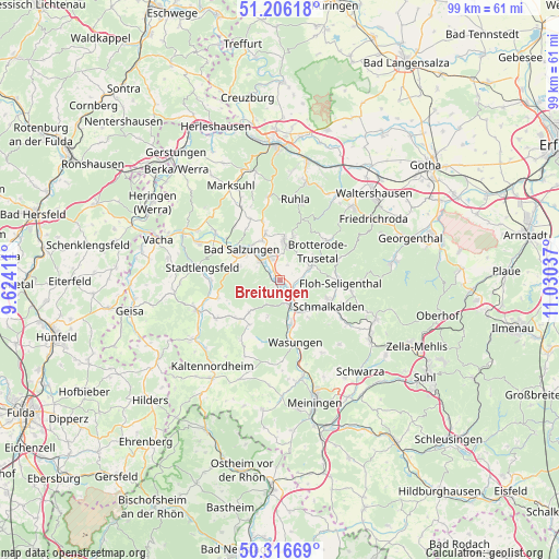
Breitungen GPS coordinates[2]
50° 45' 48.78" North, 10° 19' 38.064" East
| Map corner | latitude | longitude |
|---|---|---|
| Upper-left | 51.20618°, | 9.62411° |
| Center: | 50.76355°, | 10.32724° |
| Lower-right: | 50.31669°, | 11.03037° |
| Map W x H: | 98.9×98.9 km | = 61.5×61.5mi |
| max Lat: | 55.01917° ⇑46.5% North |
| Breitungen: | 50.76355° |
| min Lat: | ⇓53.5% South 47.40724° |
| min Long | Breitungen | max Long |
| 5.92978° | 10.32724° | 14.98853° |
| W 55.9%⇐ | ⇒44.1% E |
Elevation
Elevation of Breitungen is 252 m = 827 ft, and this is 2.9 m = 10 ft above average elevation for this country.
| Max E: |
1256 m = 4121 ft | 45.9% |
| Breitungen | 252 m 827 ft | |
| Avg. | 249.1 m = 817 ft | |
Min E: |
-5 m = -16 ft | 54.1% |
See also: Germany elevation on elevation.city.
Geographical zone
Breitungen is located in North temperate zone (between Tropic of Cancer and the Arctic Circle). Distance of this North polar circle is 1756.8 km =1091.6 mi to North.| Distance of | km | miles | from Breitungen |
|---|---|---|---|
| North Pole | 4362.7 | 2710.9 | to North |
| Arctic Circle | 1756.8 | 1091.6 | to North |
| Tropic Cancer | 3038.5 | 1888 | to South |
| Equator | 5644.4 | 3507.3 | to South |


Nearby cities:
15 places around Breitungen: (largest is in red/bold)
• Bad Liebenstein
6 km =3.7 mi,  16°
16°
• Bad Salzungen
8.5 km =5.3 mi,  310°
310°
• Barchfeld
4.5 km =2.8 mi,  334°
334°
• Brotterode
10.6 km =6.6 mi,  50°
50°
• Fambach
4.4 km =2.7 mi,  140°
140°
• Immelborn
4.7 km =2.9 mi, 312°
• Leimbach
10.7 km =6.6 mi,  303°
303°
• Rosa
7.9 km =4.9 mi,  223°
223°
• Roßdorf
10.5 km =6.5 mi,  227°
227°
• Schmalkalden
9.5 km =5.9 mi,  119°
119°
• Schwallungen
8.2 km =5.1 mi,  165°
165°
• Schweina
6.9 km =4.3 mi,  6°
6°
• Steinbach
8.2 km =5.1 mi, 18°
• Trusetal
6.7 km =4.2 mi,  70°
70°
• Wernshausen
4.7 km =2.9 mi,  159°
159°
In other languages:
- In German: Breitungen/Werra
- In Italian: Breitungen/Werra
- In Russian: Брайтунген
- In Chinese: 布赖通根
Sources, notices
• [Note1] Compared only with cities in Germany existing in our database
• [Src1] Map data: © OpenStreetMap contributors (CC-BY-SA)
• [Src2] Other city data from geonames.org with taken over terms of usage.
• [Src3] Geographical zone / Annual Mean Temperature by Robert A. Rohde @ Wikipedia
