Schmalkalden geodata
Schmalkalden (Thuringia) is a populated place; located in Germany in Europe/Berlin (GMT+1) time zone. With population of 17,710 people, there are 899 cities with bigger population in this country. Compared to other cities in Germany, 52.7% of cities are located further ↓South; 57.9% of cities are located further ←West and 60.2% of cities have lower elevation than Schmalkalden. Note1
Administrative division(s):
- Level 1: Thuringia
- Level 3: Landkreis Schmalkalden-Meiningen
- Level 4: Schmalkalden, Kurort


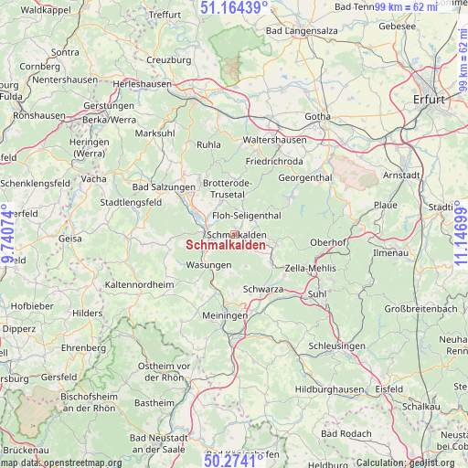
Schmalkalden GPS coordinates[2]
50° 43' 16.896" North, 10° 26' 37.896" East
| Map corner | latitude | longitude |
|---|---|---|
| Upper-left | 51.16439°, | 9.74074° |
| Center: | 50.72136°, | 10.44386° |
| Lower-right: | 50.2741°, | 11.14699° |
| Map W x H: | 99×99 km | = 61.5×61.5mi |
| max Lat: | 55.01917° ⇑47.3% North |
| Schmalkalden: | 50.72136° |
| min Lat: | ⇓52.7% South 47.40724° |
| min Long | Schmalkalden | max Long |
| 5.92978° | 10.44386° | 14.98853° |
| W 57.9%⇐ | ⇒42.1% E |
Elevation
Elevation of Schmalkalden is 291 m = 955 ft, and this is 41.9 m = 137 ft above average elevation for this country.
| Max E: |
1256 m = 4121 ft | 39.8% |
| Schmalkalden | 291 m 955 ft | |
| Avg. | 249.1 m = 817 ft | |
Min E: |
-5 m = -16 ft | 60.2% |
See also: Germany elevation on elevation.city.
Geographical zone
Schmalkalden is located in North temperate zone (between Tropic of Cancer and the Arctic Circle). Distance of this North polar circle is 1761.5 km =1094.5 mi to North.| Distance of | km | miles | from Schmalkalden |
|---|---|---|---|
| North Pole | 4367.4 | 2713.8 | to North |
| Arctic Circle | 1761.5 | 1094.5 | to North |
| Tropic Cancer | 3033.8 | 1885.1 | to South |
| Equator | 5639.7 | 3504.3 | to South |


Nearby cities:
15 places around Schmalkalden: (largest is in red/bold)
• Altersbach
6.7 km =4.2 mi,  110°
110°
• Breitenbach
4.9 km =3 mi,  137°
137°
• Breitungen
9.5 km =5.9 mi,  299°
299°
• Christes
6.7 km =4.2 mi,  155°
155°
• Fambach
5.6 km =3.5 mi,  283°
283°
• Metzels
8.3 km =5.2 mi,  184°
184°
• Pappenheim
8.6 km =5.3 mi,  14°
14°
• Rotterode
7.8 km =4.8 mi,  97°
97°
• Schwallungen
6.9 km =4.3 mi,  242°
242°
• Springstille
7 km =4.3 mi,  122°
122°
• Steinbach-Hallenberg
9 km =5.6 mi, 108°
• Trusetal
7.2 km =4.5 mi,  344°
344°
• Unterschönau
9.8 km =6.1 mi,  93°
93°
• Wasungen
8.4 km =5.2 mi,  218°
218°
• Wernshausen
6.6 km =4.1 mi,  272°
272°
In other languages:
- In Spanish: Esmalcalda
- In Italian: Smalcalda
- In Russian: Шмалькальден
- In Chinese: 施马尔卡尔登
Sources, notices
• [Note1] Compared only with cities in Germany existing in our database
• [Src1] Map data: © OpenStreetMap contributors (CC-BY-SA)
• [Src2] Other city data from geonames.org with taken over terms of usage.
• [Src3] Geographical zone / Annual Mean Temperature by Robert A. Rohde @ Wikipedia
