Ingeleben geodata
Ingeleben (Lower Saxony) is a seat of a fourth-order administrative division; located in Germany in Europe/Berlin (GMT+2) time zone. With population of 454 people, there are 9524 cities with bigger population in this country. Compared to other cities in Germany, 73.1% of cities are located further ↓South; 65.1% of cities are located further ←West and 66.7% of cities have higher elevation than Ingeleben. Note1


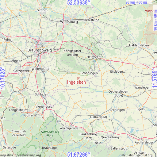
Ingeleben GPS coordinates[2]
52° 6' 23.796" North, 10° 52' 24.132" East
| Map corner | latitude | longitude |
|---|---|---|
| Upper-left | 52.53638°, | 10.17025° |
| Center: | 52.10661°, | 10.87337° |
| Lower-right: | 51.67266°, | 11.5765° |
| Map W x H: | 96×96 km | = 59.7×59.7mi |
| max Lat: | 55.01917° ⇑26.9% North |
| Ingeleben: | 52.10661° |
| min Lat: | ⇓73.1% South 47.40724° |
| min Long | Ingeleben | max Long |
| 5.92978° | 10.87337° | 14.98853° |
| W 65.1%⇐ | ⇒34.9% E |
Elevation
Elevation of Ingeleben is 110 m = 361 ft, and this is 139.1 m = 456 ft below average elevation for this country.
| Max E: |
1256 m = 4121 ft | 66.7% |
| Avg. | 249.1 m = 817 ft | |
| Ingeleben | 110 m = 361 ft | |
Min E: |
-5 m = -16 ft | 33.3% |
See also: Germany elevation on elevation.city.
Geographical zone
Ingeleben is located in North temperate zone (between Tropic of Cancer and the Arctic Circle). Distance of this North polar circle is 1607.5 km =998.9 mi to North.| Distance of | km | miles | from Ingeleben |
|---|---|---|---|
| North Pole | 4213.4 | 2618.1 | to North |
| Arctic Circle | 1607.5 | 998.9 | to North |
| Tropic Cancer | 3187.8 | 1980.8 | to South |
| Equator | 5793.7 | 3600 | to South |


Nearby cities:
15 places around Ingeleben: (largest is in red/bold)
• Beierstedt
3.8 km =2.4 mi,  196°
196°
• Dahlum
3.4 km =2.1 mi,  331°
331°
• Gevensleben
4.8 km =3 mi,  226°
226°
• Hötensleben
10.3 km =6.4 mi,  81°
81°
• Jerxheim
3.3 km =2.1 mi,  148°
148°
• Roklum
10.1 km =6.3 mi,  243°
243°
• Räbke
9.9 km =6.2 mi,  2°
2°
• Schöningen
7.3 km =4.5 mi,  61°
61°
• Schöppenstedt
7.9 km =4.9 mi,  300°
300°
• Söllingen
4 km =2.5 mi,  117°
117°
• Twieflingen
3.6 km =2.2 mi, 55°
• Uehrde
7.4 km =4.6 mi,  263°
263°
• Warberg
8.9 km =5.5 mi,  20°
20°
• Winnigstedt
8.4 km =5.2 mi, 237°
• Wolsdorf
10.4 km =6.5 mi,  25°
25°
Sources, notices
• [Note1] Compared only with cities in Germany existing in our database
• [Src1] Map data: © OpenStreetMap contributors (CC-BY-SA)
• [Src2] Other city data from geonames.org with taken over terms of usage.
• [Src3] Geographical zone / Annual Mean Temperature by Robert A. Rohde @ Wikipedia
