Schönfeld geodata
Schönfeld (Saxony) is a seat of a fourth-order administrative division; located in Germany in Europe/Berlin (GMT+2) time zone. With population of 2,021 people, there are 5041 cities with bigger population in this country. Compared to other cities in Germany, 63.2% of cities are located further ↓South; 96.8% of cities are located further ←West and 62.2% of cities have higher elevation than Schönfeld. Note1


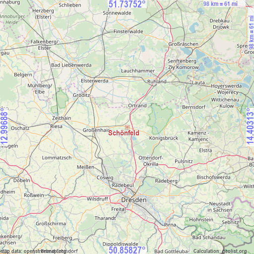
Schönfeld GPS coordinates[2]
51° 18' 0" North, 13° 42' 0" East
| Map corner | latitude | longitude |
|---|---|---|
| Upper-left | 51.73752°, | 12.99688° |
| Center: | 51.3°, | 13.7° |
| Lower-right: | 50.85827°, | 14.40313° |
| Map W x H: | 97.8×97.8 km | = 60.8×60.8mi |
| max Lat: | 55.01917° ⇑36.8% North |
| Schönfeld: | 51.3° |
| min Lat: | ⇓63.2% South 47.40724° |
| min Long | Schönfeld | max Long |
| 5.92978° | 13.7° | 14.98853° |
| W 96.8%⇐ | ⇒3.2% E |
Elevation
Elevation of Schönfeld is 137 m = 449 ft, and this is 112.1 m = 368 ft below average elevation for this country.
| Max E: |
1256 m = 4121 ft | 62.2% |
| Avg. | 249.1 m = 817 ft | |
| Schönfeld | 137 m = 449 ft | |
Min E: |
-5 m = -16 ft | 37.8% |
See also: Germany elevation on elevation.city.
Geographical zone
Schönfeld is located in North temperate zone (between Tropic of Cancer and the Arctic Circle). Distance of this North polar circle is 1697.1 km =1054.5 mi to North.| Distance of | km | miles | from Schönfeld |
|---|---|---|---|
| North Pole | 4303 | 2673.8 | to North |
| Arctic Circle | 1697.1 | 1054.5 | to North |
| Tropic Cancer | 3098.1 | 1925.1 | to South |
| Equator | 5704 | 3544.3 | to South |


Nearby cities:
15 places around Schönfeld: (largest is in red/bold)
• Ebersbach
8.2 km =5.1 mi,  205°
205°
• Frauendorf
13.7 km =8.5 mi,  20°
20°
• Großenhain
11.6 km =7.2 mi,  264°
264°
• Großkmehlen
9 km =5.6 mi,  11°
11°
• Großthiemig
9.6 km =6 mi,  345°
345°
• Hirschfeld
10.9 km =6.8 mi,  328°
328°
• Kroppen
11.6 km =7.2 mi,  36°
36°
• Lampertswalde
2 km =1.2 mi,  307°
307°
• Laußnitz
13.9 km =8.6 mi,  113°
113°
• Lindenau
11.4 km =7.1 mi, 11°
• Ortrand
9.3 km =5.8 mi,  26°
26°
• Priestewitz
13.9 km =8.6 mi,  246°
246°
• Radeburg
9.6 km =6 mi,  168°
168°
• Tauscha
7.9 km =4.9 mi,  118°
118°
• Thiendorf
3 km =1.9 mi,  103°
103°
Sources, notices
• [Note1] Compared only with cities in Germany existing in our database
• [Src1] Map data: © OpenStreetMap contributors (CC-BY-SA)
• [Src2] Other city data from geonames.org with taken over terms of usage.
• [Src3] Geographical zone / Annual Mean Temperature by Robert A. Rohde @ Wikipedia
