Großenhain geodata
Großenhain (Saxony) is a populated place; located in Germany in Europe/Berlin (GMT+2) time zone. With population of 16,573 people, there are 954 cities with bigger population in this country. Compared to other cities in Germany, 63.1% of cities are located further ↓South; 95.9% of cities are located further ←West and 65.4% of cities have higher elevation than Großenhain. Note1


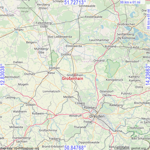
Großenhain GPS coordinates[2]
51° 17' 22.236" North, 13° 32' 0.6" East
| Map corner | latitude | longitude |
|---|---|---|
| Upper-left | 51.72713°, | 12.83038° |
| Center: | 51.28951°, | 13.5335° |
| Lower-right: | 50.84768°, | 14.23663° |
| Map W x H: | 97.8×97.8 km | = 60.8×60.8mi |
| max Lat: | 55.01917° ⇑36.9% North |
| Großenhain: | 51.28951° |
| min Lat: | ⇓63.1% South 47.40724° |
| min Long | Großenhain | max Long |
| 5.92978° | 13.5335° | 14.98853° |
| W 95.9%⇐ | ⇒4.1% E |
Elevation
Elevation of Großenhain is 118 m = 387 ft, and this is 131.1 m = 430 ft below average elevation for this country.
| Max E: |
1256 m = 4121 ft | 65.4% |
| Avg. | 249.1 m = 817 ft | |
| Großenhain | 118 m = 387 ft | |
Min E: |
-5 m = -16 ft | 34.6% |
See also: Germany elevation on elevation.city.
Geographical zone
Großenhain is located in North temperate zone (between Tropic of Cancer and the Arctic Circle). Distance of this North polar circle is 1698.3 km =1055.3 mi to North.| Distance of | km | miles | from Großenhain |
|---|---|---|---|
| North Pole | 4304.2 | 2674.5 | to North |
| Arctic Circle | 1698.3 | 1055.3 | to North |
| Tropic Cancer | 3096.9 | 1924.3 | to South |
| Equator | 5702.9 | 3543.6 | to South |


Nearby cities:
15 places around Großenhain: (largest is in red/bold)
• Ebersbach
10.2 km =6.3 mi,  127°
127°
• Glaubitz
11.5 km =7.1 mi,  290°
290°
• Großthiemig
13.9 km =8.6 mi,  41°
41°
• Gröden
12.5 km =7.8 mi,  10°
10°
• Hirschfeld
11.9 km =7.4 mi,  28°
28°
• Lampertswalde
10.3 km =6.4 mi,  76°
76°
• Merzdorf
12.3 km =7.6 mi,  359°
359°
• Niederau
12.5 km =7.8 mi,  176°
176°
• Nünchritz
10.4 km =6.5 mi,  276°
276°
• Priestewitz
4.5 km =2.8 mi,  194°
194°
• Schönfeld
11.6 km =7.2 mi, 84°
• Weißig
6.4 km =4 mi,  272°
272°
• Wildenhain
4.4 km =2.7 mi,  297°
297°
• Wülknitz
12.6 km =7.8 mi,  312°
312°
• Zabeltitz
7.2 km =4.5 mi,  343°
343°
Sources, notices
• [Note1] Compared only with cities in Germany existing in our database
• [Src1] Map data: © OpenStreetMap contributors (CC-BY-SA)
• [Src2] Other city data from geonames.org with taken over terms of usage.
• [Src3] Geographical zone / Annual Mean Temperature by Robert A. Rohde @ Wikipedia
