Radeburg geodata
Radeburg (Saxony) is a populated place; located in Germany in Europe/Berlin (GMT+2) time zone. With population of 7,812 people, there are 1986 cities with bigger population in this country. Compared to other cities in Germany, 61.8% of cities are located further ↓South; 96.9% of cities are located further ←West and 60.3% of cities have higher elevation than Radeburg. Note1


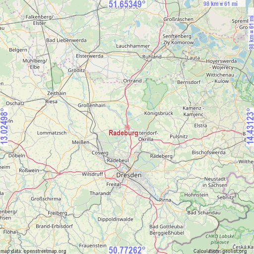
Radeburg GPS coordinates[2]
51° 12' 54.576" North, 13° 43' 41.16" East
| Map corner | latitude | longitude |
|---|---|---|
| Upper-left | 51.65349°, | 13.02498° |
| Center: | 51.21516°, | 13.7281° |
| Lower-right: | 50.77262°, | 14.43123° |
| Map W x H: | 97.9×97.9 km | = 60.8×60.8mi |
| max Lat: | 55.01917° ⇑38.2% North |
| Radeburg: | 51.21516° |
| min Lat: | ⇓61.8% South 47.40724° |
| min Long | Radeburg | max Long |
| 5.92978° | 13.7281° | 14.98853° |
| W 96.9%⇐ | ⇒3.1% E |
Elevation
Elevation of Radeburg is 150 m = 492 ft, and this is 99.1 m = 325 ft below average elevation for this country.
| Max E: |
1256 m = 4121 ft | 60.3% |
| Avg. | 249.1 m = 817 ft | |
| Radeburg | 150 m = 492 ft | |
Min E: |
-5 m = -16 ft | 39.7% |
See also: Germany elevation on elevation.city.
Geographical zone
Radeburg is located in North temperate zone (between Tropic of Cancer and the Arctic Circle). Distance of this North polar circle is 1706.6 km =1060.4 mi to North.| Distance of | km | miles | from Radeburg |
|---|---|---|---|
| North Pole | 4312.5 | 2679.7 | to North |
| Arctic Circle | 1706.6 | 1060.4 | to North |
| Tropic Cancer | 3088.7 | 1919.2 | to South |
| Equator | 5694.6 | 3538.5 | to South |


Nearby cities:
15 places around Radeburg: (largest is in red/bold)
• Coswig
13.7 km =8.5 mi,  227°
227°
• Ebersbach
5.8 km =3.6 mi,  290°
290°
• Höckendorf
12.7 km =7.9 mi,  85°
85°
• Königsbrück
13.5 km =8.4 mi,  66°
66°
• Lampertswalde
11.2 km =7 mi,  341°
341°
• Laußnitz
11.5 km =7.1 mi, 70°
• Moritzburg
7.1 km =4.4 mi,  208°
208°
• Niederau
13.4 km =8.3 mi,  251°
251°
• Ottendorf-Okrilla
8.1 km =5 mi,  115°
115°
• Radebeul
13 km =8.1 mi,  201°
201°
• Schönfeld
9.6 km =6 mi,  348°
348°
• Tauscha
7.6 km =4.7 mi,  41°
41°
• Thiendorf
8.8 km =5.5 mi,  5°
5°
• Wachau
13.8 km =8.6 mi, 115°
• Weinböhla
12.5 km =7.8 mi,  244°
244°
Sources, notices
• [Note1] Compared only with cities in Germany existing in our database
• [Src1] Map data: © OpenStreetMap contributors (CC-BY-SA)
• [Src2] Other city data from geonames.org with taken over terms of usage.
• [Src3] Geographical zone / Annual Mean Temperature by Robert A. Rohde @ Wikipedia
