Schönewörde geodata
Schönewörde (Lower Saxony) is a seat of a fourth-order administrative division; located in Germany in Europe/Berlin (GMT+2) time zone. With population of 966 people, there are 7288 cities with bigger population in this country. Compared to other cities in Germany, 79.1% of cities are located further ↓South; 61.3% of cities are located further ←West and 75.5% of cities have higher elevation than Schönewörde. Note1


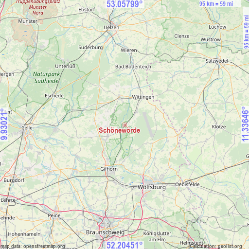
Schönewörde GPS coordinates[2]
52° 37' 59.988" North, 10° 37' 59.988" East
| Map corner | latitude | longitude |
|---|---|---|
| Upper-left | 53.05799°, | 9.93021° |
| Center: | 52.63333°, | 10.63333° |
| Lower-right: | 52.20451°, | 11.33646° |
| Map W x H: | 94.9×94.9 km | = 59×59mi |
| max Lat: | 55.01917° ⇑20.9% North |
| Schönewörde: | 52.63333° |
| min Lat: | ⇓79.1% South 47.40724° |
| min Long | Schönewörde | max Long |
| 5.92978° | 10.63333° | 14.98853° |
| W 61.3%⇐ | ⇒38.7% E |
Elevation
Elevation of Schönewörde is 61 m = 200 ft, and this is 188.1 m = 617 ft below average elevation for this country.
| Max E: |
1256 m = 4121 ft | 75.5% |
| Avg. | 249.1 m = 817 ft | |
| Schönewörde | 61 m = 200 ft | |
Min E: |
-5 m = -16 ft | 24.5% |
See also: Germany elevation on elevation.city.
Geographical zone
Schönewörde is located in North temperate zone (between Tropic of Cancer and the Arctic Circle). Distance of this North polar circle is 1548.9 km =962.4 mi to North.| Distance of | km | miles | from Schönewörde |
|---|---|---|---|
| North Pole | 4154.8 | 2581.7 | to North |
| Arctic Circle | 1548.9 | 962.4 | to North |
| Tropic Cancer | 3246.4 | 2017.2 | to South |
| Equator | 5852.3 | 3636.4 | to South |


Nearby cities:
15 places around Schönewörde: (largest is in red/bold)
• Barwedel
15.7 km =9.8 mi,  142°
142°
• Bokensdorf
15.9 km =9.9 mi,  159°
159°
• Dedelstorf
11.7 km =7.3 mi,  309°
309°
• Groß Oesingen
11.6 km =7.2 mi,  277°
277°
• Hankensbüttel
11.3 km =7 mi,  348°
348°
• Jembke
17.3 km =10.7 mi,  148°
148°
• Obernholz
15 km =9.3 mi, 350°
• Sassenburg
13 km =8.1 mi,  180°
180°
• Steinhorst
16.7 km =10.4 mi,  289°
289°
• Tiddische
17.2 km =10.7 mi, 139°
• Ummern
14.4 km =8.9 mi,  250°
250°
• Wagenhoff
11.7 km =7.3 mi,  219°
219°
• Wahrenholz
2.9 km =1.8 mi,  230°
230°
• Wesendorf
7.7 km =4.8 mi,  241°
241°
• Wittingen
12.5 km =7.8 mi,  33°
33°
Sources, notices
• [Note1] Compared only with cities in Germany existing in our database
• [Src1] Map data: © OpenStreetMap contributors (CC-BY-SA)
• [Src2] Other city data from geonames.org with taken over terms of usage.
• [Src3] Geographical zone / Annual Mean Temperature by Robert A. Rohde @ Wikipedia
