Wittingen geodata
Wittingen (Lower Saxony) is a populated place; located in Germany in Europe/Berlin (GMT+2) time zone. With population of 12,427 people, there are 1312 cities with bigger population in this country. Compared to other cities in Germany, 79.9% of cities are located further ↓South; 63.1% of cities are located further ←West and 71.1% of cities have higher elevation than Wittingen. Note1


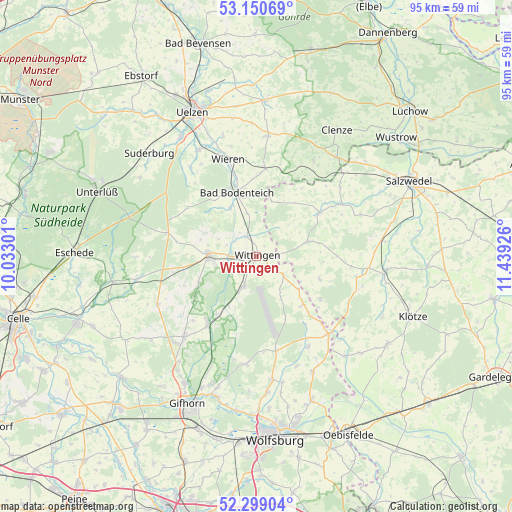
Wittingen GPS coordinates[2]
52° 43' 36.984" North, 10° 44' 10.068" East
| Map corner | latitude | longitude |
|---|---|---|
| Upper-left | 53.15069°, | 10.03301° |
| Center: | 52.72694°, | 10.73613° |
| Lower-right: | 52.29904°, | 11.43926° |
| Map W x H: | 94.7×94.7 km | = 58.8×58.8mi |
| max Lat: | 55.01917° ⇑20.1% North |
| Wittingen: | 52.72694° |
| min Lat: | ⇓79.9% South 47.40724° |
| min Long | Wittingen | max Long |
| 5.92978° | 10.73613° | 14.98853° |
| W 63.1%⇐ | ⇒36.9% E |
Elevation
Elevation of Wittingen is 84 m = 276 ft, and this is 165.1 m = 542 ft below average elevation for this country.
| Max E: |
1256 m = 4121 ft | 71.1% |
| Avg. | 249.1 m = 817 ft | |
| Wittingen | 84 m = 276 ft | |
Min E: |
-5 m = -16 ft | 28.9% |
See also: Germany elevation on elevation.city.
Geographical zone
Wittingen is located in North temperate zone (between Tropic of Cancer and the Arctic Circle). Distance of this North polar circle is 1538.5 km =956 mi to North.| Distance of | km | miles | from Wittingen |
|---|---|---|---|
| North Pole | 4144.4 | 2575.2 | to North |
| Arctic Circle | 1538.5 | 956 | to North |
| Tropic Cancer | 3256.8 | 2023.7 | to South |
| Equator | 5862.7 | 3642.9 | to South |


Nearby cities:
15 places around Wittingen: (largest is in red/bold)
• Bodenteich
12.1 km =7.5 mi,  342°
342°
• Brome
19.6 km =12.2 mi,  136°
136°
• Dedelstorf
16.2 km =10.1 mi,  259°
259°
• Dähre
13.9 km =8.6 mi,  55°
55°
• Hankensbüttel
9.2 km =5.7 mi,  274°
274°
• Jübar
12.4 km =7.7 mi,  109°
109°
• Lüder
10.2 km =6.3 mi,  332°
332°
• Obernholz
10.3 km =6.4 mi,  295°
295°
• Schönewörde
12.5 km =7.8 mi,  213°
213°
• Soltendieck
16.4 km =10.2 mi,  5°
5°
• Sprakensehl
17 km =10.6 mi,  285°
285°
• Tülau
19.3 km =12 mi,  150°
150°
• Wahrenholz
15.3 km =9.5 mi,  216°
216°
• Wesendorf
19.7 km =12.2 mi, 224°
• Wieren
18.4 km =11.4 mi, 343°
Sources, notices
• [Note1] Compared only with cities in Germany existing in our database
• [Src1] Map data: © OpenStreetMap contributors (CC-BY-SA)
• [Src2] Other city data from geonames.org with taken over terms of usage.
• [Src3] Geographical zone / Annual Mean Temperature by Robert A. Rohde @ Wikipedia
