Dedelstorf geodata
Dedelstorf (Lower Saxony) is a seat of a fourth-order administrative division; located in Germany in Europe/Berlin (GMT+2) time zone. With population of 1,515 people, there are 5850 cities with bigger population in this country. Compared to other cities in Germany, 79.7% of cities are located further ↓South; 58.9% of cities are located further ←West and 69.7% of cities have higher elevation than Dedelstorf. Note1


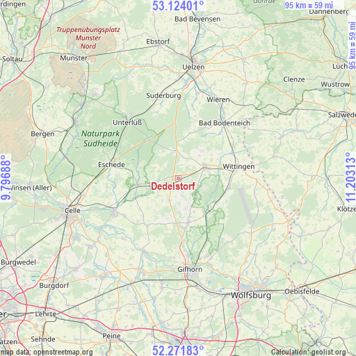
Dedelstorf GPS coordinates[2]
52° 42' 0" North, 10° 30' 0" East
| Map corner | latitude | longitude |
|---|---|---|
| Upper-left | 53.12401°, | 9.79688° |
| Center: | 52.7°, | 10.5° |
| Lower-right: | 52.27183°, | 11.20313° |
| Map W x H: | 94.8×94.8 km | = 58.9×58.9mi |
| max Lat: | 55.01917° ⇑20.3% North |
| Dedelstorf: | 52.7° |
| min Lat: | ⇓79.7% South 47.40724° |
| min Long | Dedelstorf | max Long |
| 5.92978° | 10.5° | 14.98853° |
| W 58.9%⇐ | ⇒41.1% E |
Elevation
Elevation of Dedelstorf is 93 m = 305 ft, and this is 156.1 m = 512 ft below average elevation for this country.
| Max E: |
1256 m = 4121 ft | 69.7% |
| Avg. | 249.1 m = 817 ft | |
| Dedelstorf | 93 m = 305 ft | |
Min E: |
-5 m = -16 ft | 30.3% |
See also: Germany elevation on elevation.city.
Geographical zone
Dedelstorf is located in North temperate zone (between Tropic of Cancer and the Arctic Circle). Distance of this North polar circle is 1541.5 km =957.8 mi to North.| Distance of | km | miles | from Dedelstorf |
|---|---|---|---|
| North Pole | 4147.4 | 2577.1 | to North |
| Arctic Circle | 1541.5 | 957.8 | to North |
| Tropic Cancer | 3253.8 | 2021.8 | to South |
| Equator | 5859.7 | 3641 | to South |


Nearby cities:
15 places around Dedelstorf: (largest is in red/bold)
• Eldingen
11.4 km =7.1 mi,  260°
260°
• Groß Oesingen
6.3 km =3.9 mi,  202°
202°
• Hankensbüttel
7.7 km =4.8 mi,  61°
61°
• Hohne
15.1 km =9.4 mi,  213°
213°
• Lüder
16.5 km =10.3 mi,  42°
42°
• Obernholz
9.9 km =6.2 mi, 41°
• Scharnhorst
14.7 km =9.1 mi,  277°
277°
• Schönewörde
11.7 km =7.3 mi,  129°
129°
• Sprakensehl
7.4 km =4.6 mi,  355°
355°
• Steinhorst
7 km =4.3 mi,  254°
254°
• Ummern
12.9 km =8 mi, 200°
• Wagenhoff
16.5 km =10.3 mi,  174°
174°
• Wahrenholz
11.5 km =7.1 mi,  143°
143°
• Wesendorf
11.3 km =7 mi, 168°
• Wittingen
16.2 km =10.1 mi,  79°
79°
Sources, notices
• [Note1] Compared only with cities in Germany existing in our database
• [Src1] Map data: © OpenStreetMap contributors (CC-BY-SA)
• [Src2] Other city data from geonames.org with taken over terms of usage.
• [Src3] Geographical zone / Annual Mean Temperature by Robert A. Rohde @ Wikipedia
