Groß Oesingen geodata
Groß Oesingen (Lower Saxony) is a seat of a fourth-order administrative division; located in Germany in Europe/Berlin (GMT+2) time zone. With population of 2,017 people, there are 5045 cities with bigger population in this country. Compared to other cities in Germany, 79.3% of cities are located further ↓South; 58.3% of cities are located further ←West and 72.1% of cities have higher elevation than Groß Oesingen. Note1


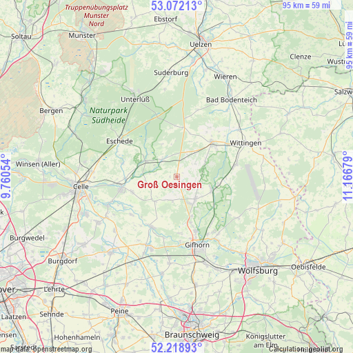
Groß Oesingen GPS coordinates[2]
52° 38' 51.396" North, 10° 27' 49.176" East
| Map corner | latitude | longitude |
|---|---|---|
| Upper-left | 53.07213°, | 9.76054° |
| Center: | 52.64761°, | 10.46366° |
| Lower-right: | 52.21893°, | 11.16679° |
| Map W x H: | 94.9×94.9 km | = 59×59mi |
| max Lat: | 55.01917° ⇑20.7% North |
| Groß Oesingen: | 52.64761° |
| min Lat: | ⇓79.3% South 47.40724° |
| min Long | Groß Oesingen | max Long |
| 5.92978° | 10.46366° | 14.98853° |
| W 58.3%⇐ | ⇒41.7% E |
Elevation
Elevation of Groß Oesingen is 77 m = 253 ft, and this is 172.1 m = 565 ft below average elevation for this country.
| Max E: |
1256 m = 4121 ft | 72.1% |
| Avg. | 249.1 m = 817 ft | |
| Groß Oesingen | 77 m = 253 ft | |
Min E: |
-5 m = -16 ft | 27.9% |
See also: Germany elevation on elevation.city.
Geographical zone
Groß Oesingen is located in North temperate zone (between Tropic of Cancer and the Arctic Circle). Distance of this North polar circle is 1547.3 km =961.4 mi to North.| Distance of | km | miles | from Groß Oesingen |
|---|---|---|---|
| North Pole | 4153.2 | 2580.7 | to North |
| Arctic Circle | 1547.3 | 961.4 | to North |
| Tropic Cancer | 3247.9 | 2018.2 | to South |
| Equator | 5853.9 | 3637.4 | to South |


Nearby cities:
15 places around Groß Oesingen: (largest is in red/bold)
• Ahnsbeck
12.7 km =7.9 mi,  251°
251°
• Beedenbostel
13.8 km =8.6 mi,  267°
267°
• Dedelstorf
6.3 km =3.9 mi,  22°
22°
• Eldingen
9.6 km =6 mi,  294°
294°
• Hankensbüttel
13.2 km =8.2 mi,  43°
43°
• Hohne
8.9 km =5.5 mi,  221°
221°
• Lachendorf
14.8 km =9.2 mi,  256°
256°
• Scharnhorst
14.4 km =8.9 mi,  302°
302°
• Schönewörde
11.6 km =7.2 mi,  97°
97°
• Sprakensehl
13.4 km =8.3 mi,  8°
8°
• Steinhorst
5.8 km =3.6 mi,  312°
312°
• Ummern
6.6 km =4.1 mi,  198°
198°
• Wagenhoff
11.3 km =7 mi,  159°
159°
• Wahrenholz
9.8 km =6.1 mi,  110°
110°
• Wesendorf
7.1 km =4.4 mi,  138°
138°
Sources, notices
• [Note1] Compared only with cities in Germany existing in our database
• [Src1] Map data: © OpenStreetMap contributors (CC-BY-SA)
• [Src2] Other city data from geonames.org with taken over terms of usage.
• [Src3] Geographical zone / Annual Mean Temperature by Robert A. Rohde @ Wikipedia
