Adorf geodata
Adorf (Saxony) is a populated place; located in Germany in Europe/Berlin (GMT+2) time zone. With population of 5,806 people, there are 2526 cities with bigger population in this country. Compared to other cities in Germany, 56.2% of cities are located further ↑North; 85.3% of cities are located further ←West and 81.4% of cities have lower elevation than Adorf. Note1


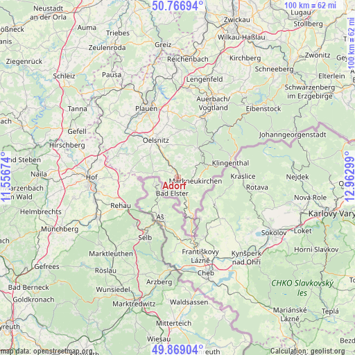
Adorf GPS coordinates[2]
50° 19' 12.396" North, 12° 15' 35.496" East
| Map corner | latitude | longitude |
|---|---|---|
| Upper-left | 50.76694°, | 11.55674° |
| Center: | 50.32011°, | 12.25986° |
| Lower-right: | 49.86904°, | 12.96299° |
| Map W x H: | 99.8×99.8 km | = 62×62mi |
| max Lat: | 55.01917° ⇑56.2% North |
| Adorf: | 50.32011° |
| min Lat: | ⇓43.8% South 47.40724° |
| min Long | Adorf | max Long |
| 5.92978° | 12.25986° | 14.98853° |
| W 85.3%⇐ | ⇒14.7% E |
Elevation
Elevation of Adorf is 443 m = 1453 ft, and this is 193.9 m = 636 ft above average elevation for this country.
| Max E: |
1256 m = 4121 ft | 18.6% |
| Adorf | 443 m 1453 ft | |
| Avg. | 249.1 m = 817 ft | |
Min E: |
-5 m = -16 ft | 81.4% |
See also: Germany elevation on elevation.city.
Geographical zone
Adorf is located in North temperate zone (between Tropic of Cancer and the Arctic Circle). Distance of this North polar circle is 1806.1 km =1122.3 mi to North.| Distance of | km | miles | from Adorf |
|---|---|---|---|
| North Pole | 4412 | 2741.5 | to North |
| Arctic Circle | 1806.1 | 1122.3 | to North |
| Tropic Cancer | 2989.2 | 1857.4 | to South |
| Equator | 5595.1 | 3476.6 | to South |


Nearby cities:
15 places around Adorf: (largest is in red/bold)
• Bad Brambach
12.2 km =7.6 mi,  160°
160°
• Bad Elster
4.6 km =2.9 mi,  203°
203°
• Bösenbrunn
14.2 km =8.8 mi,  307°
307°
• Eichigt
7.4 km =4.6 mi,  296°
296°
• Erlbach
7.6 km =4.7 mi,  92°
92°
• Haag
13.2 km =8.2 mi,  262°
262°
• Markneukirchen
5 km =3.1 mi,  101°
101°
• Oelsnitz
12.3 km =7.6 mi,  328°
328°
• Pöhl
9.5 km =5.9 mi,  31°
31°
• Regnitzlosau
15.1 km =9.4 mi, 261°
• Schöneck
9.2 km =5.7 mi, 31°
• Tirpersdorf
12.6 km =7.8 mi,  356°
356°
• Triebel
11.4 km =7.1 mi, 300°
• Werda
13.5 km =8.4 mi,  13°
13°
• Zwota
12 km =7.5 mi,  73°
73°
Sources, notices
• [Note1] Compared only with cities in Germany existing in our database
• [Src1] Map data: © OpenStreetMap contributors (CC-BY-SA)
• [Src2] Other city data from geonames.org with taken over terms of usage.
• [Src3] Geographical zone / Annual Mean Temperature by Robert A. Rohde @ Wikipedia
