Schönebeck geodata
Schönebeck (Saxony-Anhalt) is a populated place; located in Germany in Europe/Berlin (GMT+2) time zone. With population of 34,301 people, there are 391 cities with bigger population in this country. Compared to other cities in Germany, 72.2% of cities are located further ↓South; 77.6% of cities are located further ←West and 77.9% of cities have higher elevation than Schönebeck. Note1
Administrative division(s):
- Level 1: Saxony-Anhalt
- Level 3: Salzlandkreis
- Level 4: Schönebeck (Elbe)


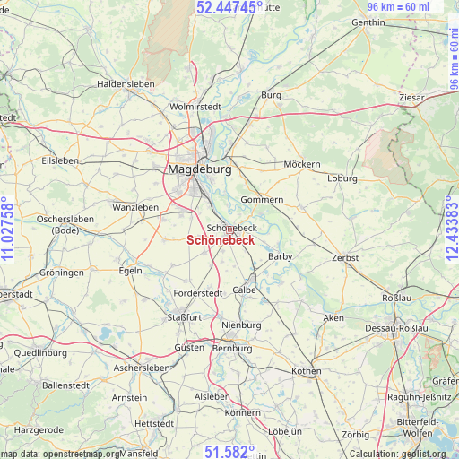
Schönebeck GPS coordinates[2]
52° 1' 0.552" North, 11° 43' 50.52" East
| Map corner | latitude | longitude |
|---|---|---|
| Upper-left | 52.44745°, | 11.02758° |
| Center: | 52.01682°, | 11.7307° |
| Lower-right: | 51.582°, | 12.43383° |
| Map W x H: | 96.2×96.2 km | = 59.8×59.8mi |
| max Lat: | 55.01917° ⇑27.8% North |
| Schönebeck: | 52.01682° |
| min Lat: | ⇓72.2% South 47.40724° |
| min Long | Schönebeck | max Long |
| 5.92978° | 11.7307° | 14.98853° |
| W 77.6%⇐ | ⇒22.4% E |
Elevation
Elevation of Schönebeck is 53 m = 174 ft, and this is 196.1 m = 643 ft below average elevation for this country.
| Max E: |
1256 m = 4121 ft | 77.9% |
| Avg. | 249.1 m = 817 ft | |
| Schönebeck | 53 m = 174 ft | |
Min E: |
-5 m = -16 ft | 22.1% |
See also: Germany elevation on elevation.city.
Geographical zone
Schönebeck is located in North temperate zone (between Tropic of Cancer and the Arctic Circle). Distance of this North polar circle is 1617.4 km =1005 mi to North.| Distance of | km | miles | from Schönebeck |
|---|---|---|---|
| North Pole | 4223.3 | 2624.2 | to North |
| Arctic Circle | 1617.4 | 1005 | to North |
| Tropic Cancer | 3177.8 | 1974.6 | to South |
| Equator | 5783.7 | 3593.8 | to South |


Nearby cities:
15 places around Schönebeck: (largest is in red/bold)
• Barby
11.8 km =7.3 mi,  117°
117°
• Biere
7 km =4.3 mi,  227°
227°
• Dannigkow
11.5 km =7.1 mi,  58°
58°
• Eggersdorf
4.7 km =2.9 mi,  197°
197°
• Eickendorf
8.6 km =5.3 mi,  206°
206°
• Gnadau
5.6 km =3.5 mi,  143°
143°
• Gommern
9 km =5.6 mi,  44°
44°
• Klein Mühlingen
7.8 km =4.8 mi,  172°
172°
• Menz
11.5 km =7.1 mi,  11°
11°
• Plötzky
6.3 km =3.9 mi,  51°
51°
• Pretzien
7.3 km =4.5 mi, 64°
• Pömmelte
7.6 km =4.7 mi,  109°
109°
• Tornitz
12.5 km =7.8 mi, 140°
• Wahlitz
10.2 km =6.3 mi,  19°
19°
• Welsleben
6.5 km =4 mi,  256°
256°
Sources, notices
• [Note1] Compared only with cities in Germany existing in our database
• [Src1] Map data: © OpenStreetMap contributors (CC-BY-SA)
• [Src2] Other city data from geonames.org with taken over terms of usage.
• [Src3] Geographical zone / Annual Mean Temperature by Robert A. Rohde @ Wikipedia
