Schömberg geodata
Schömberg (Thuringia) is a seat of a fourth-order administrative division; located in Germany in Europe/Berlin (GMT+2) time zone. With population of 117 people, there are 10792 cities with bigger population in this country. Compared to other cities in Germany, 53.5% of cities are located further ↓South; 82% of cities are located further ←West and 68.9% of cities have lower elevation than Schömberg. Note1


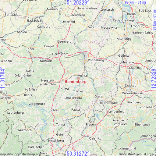
Schömberg GPS coordinates[2]
50° 45' 34.632" North, 12° 1' 12.576" East
| Map corner | latitude | longitude |
|---|---|---|
| Upper-left | 51.20229°, | 11.31704° |
| Center: | 50.75962°, | 12.02016° |
| Lower-right: | 50.31272°, | 12.72329° |
| Map W x H: | 98.9×98.9 km | = 61.5×61.5mi |
| max Lat: | 55.01917° ⇑46.5% North |
| Schömberg: | 50.75962° |
| min Lat: | ⇓53.5% South 47.40724° |
| min Long | Schömberg | max Long |
| 5.92978° | 12.02016° | 14.98853° |
| W 82%⇐ | ⇒18% E |
Elevation
Elevation of Schömberg is 350 m = 1148 ft, and this is 100.9 m = 331 ft above average elevation for this country.
| Max E: |
1256 m = 4121 ft | 31.1% |
| Schömberg | 350 m 1148 ft | |
| Avg. | 249.1 m = 817 ft | |
Min E: |
-5 m = -16 ft | 68.9% |
See also: Germany elevation on elevation.city.
Geographical zone
Schömberg is located in North temperate zone (between Tropic of Cancer and the Arctic Circle). Distance of this North polar circle is 1757.2 km =1091.9 mi to North.| Distance of | km | miles | from Schömberg |
|---|---|---|---|
| North Pole | 4363.1 | 2711.1 | to North |
| Arctic Circle | 1757.2 | 1091.9 | to North |
| Tropic Cancer | 3038 | 1887.7 | to South |
| Equator | 5643.9 | 3507 | to South |


Nearby cities:
15 places around Schömberg: (largest is in red/bold)
• Bocka
7.4 km =4.6 mi,  329°
329°
• Crimla
5 km =3.1 mi,  25°
25°
• Geroda
8.5 km =5.3 mi,  275°
275°
• Hain
7.3 km =4.5 mi,  142°
142°
• Hohenleuben
5.9 km =3.7 mi,  155°
155°
• Hohenölsen
5 km =3.1 mi,  113°
113°
• Lunzig
7.3 km =4.5 mi, 135°
• Mittelpöllnitz
7.4 km =4.6 mi,  261°
261°
• Steinsdorf
2.4 km =1.5 mi,  117°
117°
• Teichwitz
4.6 km =2.9 mi,  103°
103°
• Triebes
8.3 km =5.2 mi,  179°
179°
• Weida
3.3 km =2.1 mi,  59°
59°
• Wildetaube
8.3 km =5.2 mi,  125°
125°
• Wünschendorf
6.9 km =4.3 mi,  53°
53°
• Zedlitz
6.4 km =4 mi,  8°
8°
Sources, notices
• [Note1] Compared only with cities in Germany existing in our database
• [Src1] Map data: © OpenStreetMap contributors (CC-BY-SA)
• [Src2] Other city data from geonames.org with taken over terms of usage.
• [Src3] Geographical zone / Annual Mean Temperature by Robert A. Rohde @ Wikipedia
