Hohenleuben geodata
Hohenleuben (Thuringia) is a populated place; located in Germany in Europe/Berlin (GMT+2) time zone. With population of 1,778 people, there are 5381 cities with bigger population in this country. Compared to other cities in Germany, 52.4% of cities are located further ↓South; 82.6% of cities are located further ←West and 74.4% of cities have lower elevation than Hohenleuben. Note1


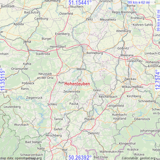
Hohenleuben GPS coordinates[2]
50° 42' 40.608" North, 12° 3' 15.372" East
| Map corner | latitude | longitude |
|---|---|---|
| Upper-left | 51.15441°, | 11.35115° |
| Center: | 50.71128°, | 12.05427° |
| Lower-right: | 50.26392°, | 12.7574° |
| Map W x H: | 99×99 km | = 61.5×61.5mi |
| max Lat: | 55.01917° ⇑47.6% North |
| Hohenleuben: | 50.71128° |
| min Lat: | ⇓52.4% South 47.40724° |
| min Long | Hohenleuben | max Long |
| 5.92978° | 12.05427° | 14.98853° |
| W 82.6%⇐ | ⇒17.4% E |
Elevation
Elevation of Hohenleuben is 393 m = 1289 ft, and this is 143.9 m = 472 ft above average elevation for this country.
| Max E: |
1256 m = 4121 ft | 25.6% |
| Hohenleuben | 393 m 1289 ft | |
| Avg. | 249.1 m = 817 ft | |
Min E: |
-5 m = -16 ft | 74.4% |
See also: Germany elevation on elevation.city.
Geographical zone
Hohenleuben is located in North temperate zone (between Tropic of Cancer and the Arctic Circle). Distance of this North polar circle is 1762.6 km =1095.2 mi to North.| Distance of | km | miles | from Hohenleuben |
|---|---|---|---|
| North Pole | 4368.5 | 2714.5 | to North |
| Arctic Circle | 1762.6 | 1095.2 | to North |
| Tropic Cancer | 3032.6 | 1884.4 | to South |
| Equator | 5638.6 | 3503.7 | to South |


Nearby cities:
15 places around Hohenleuben: (largest is in red/bold)
• Berga
9 km =5.6 mi,  59°
59°
• Hain
2.1 km =1.3 mi,  101°
101°
• Hohenölsen
4 km =2.5 mi,  33°
33°
• Kühdorf
4 km =2.5 mi, 97°
• Langenwetzendorf
4.6 km =2.9 mi,  142°
142°
• Lunzig
2.7 km =1.7 mi,  85°
85°
• Neugernsdorf
5.6 km =3.5 mi,  83°
83°
• Schömberg
5.9 km =3.7 mi,  335°
335°
• Steinsdorf
4.3 km =2.7 mi,  356°
356°
• Teichwitz
4.8 km =3 mi, 25°
• Triebes
3.8 km =2.4 mi,  219°
219°
• Weida
7 km =4.3 mi,  3°
3°
• Weißendorf
4.9 km =3 mi,  230°
230°
• Wildetaube
4.4 km =2.7 mi, 82°
• Zeulenroda
8.2 km =5.1 mi, 217°
Sources, notices
• [Note1] Compared only with cities in Germany existing in our database
• [Src1] Map data: © OpenStreetMap contributors (CC-BY-SA)
• [Src2] Other city data from geonames.org with taken over terms of usage.
• [Src3] Geographical zone / Annual Mean Temperature by Robert A. Rohde @ Wikipedia
