Weida geodata
Weida (Thuringia) is a populated place; located in Germany in Europe/Berlin (GMT+2) time zone. With population of 8,528 people, there are 1869 cities with bigger population in this country. Compared to other cities in Germany, 53.7% of cities are located further ↓South; 82.6% of cities are located further ←West and 51.9% of cities have lower elevation than Weida. Note1


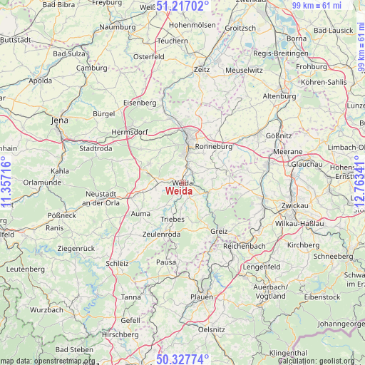
Weida GPS coordinates[2]
50° 46' 28.164" North, 12° 3' 37.008" East
| Map corner | latitude | longitude |
|---|---|---|
| Upper-left | 51.21702°, | 11.35716° |
| Center: | 50.77449°, | 12.06028° |
| Lower-right: | 50.32774°, | 12.76341° |
| Map W x H: | 98.9×98.9 km | = 61.5×61.5mi |
| max Lat: | 55.01917° ⇑46.3% North |
| Weida: | 50.77449° |
| min Lat: | ⇓53.7% South 47.40724° |
| min Long | Weida | max Long |
| 5.92978° | 12.06028° | 14.98853° |
| W 82.6%⇐ | ⇒17.4% E |
Elevation
Elevation of Weida is 239 m = 784 ft, and this is 10.1 m = 33 ft below average elevation for this country.
| Max E: |
1256 m = 4121 ft | 48.1% |
| Avg. | 249.1 m = 817 ft | |
| Weida | 239 m = 784 ft | |
Min E: |
-5 m = -16 ft | 51.9% |
See also: Germany elevation on elevation.city.
Geographical zone
Weida is located in North temperate zone (between Tropic of Cancer and the Arctic Circle). Distance of this North polar circle is 1755.6 km =1090.9 mi to North.| Distance of | km | miles | from Weida |
|---|---|---|---|
| North Pole | 4361.5 | 2710.1 | to North |
| Arctic Circle | 1755.6 | 1090.9 | to North |
| Tropic Cancer | 3039.7 | 1888.8 | to South |
| Equator | 5645.6 | 3508 | to South |


Nearby cities:
15 places around Weida: (largest is in red/bold)
• Berga
7.7 km =4.8 mi,  108°
108°
• Bocka
8.1 km =5 mi,  305°
305°
• Crimla
2.9 km =1.8 mi,  345°
345°
• Endschütz
5.5 km =3.4 mi,  75°
75°
• Hain
7.6 km =4.7 mi,  167°
167°
• Hilbersdorf
7.9 km =4.9 mi,  53°
53°
• Hohenleuben
7 km =4.3 mi,  183°
183°
• Hohenölsen
4.1 km =2.5 mi,  153°
153°
• Lunzig
7.2 km =4.5 mi,  161°
161°
• Schömberg
3.3 km =2.1 mi,  239°
239°
• Steinsdorf
2.8 km =1.7 mi,  194°
194°
• Teichwitz
3.2 km =2 mi, 149°
• Wildetaube
7.6 km =4.7 mi, 148°
• Wünschendorf
3.6 km =2.2 mi, 47°
• Zedlitz
5.1 km =3.2 mi,  338°
338°
Sources, notices
• [Note1] Compared only with cities in Germany existing in our database
• [Src1] Map data: © OpenStreetMap contributors (CC-BY-SA)
• [Src2] Other city data from geonames.org with taken over terms of usage.
• [Src3] Geographical zone / Annual Mean Temperature by Robert A. Rohde @ Wikipedia
