Schöllnach geodata
Schöllnach (Bavaria) is a populated place; located in Germany in Europe/Berlin (GMT+2) time zone. With population of 5,120 people, there are 2780 cities with bigger population in this country. Compared to other cities in Germany, 85.8% of cities are located further ↑North; 93.5% of cities are located further ←West and 72.8% of cities have lower elevation than Schöllnach. Note1
Administrative division(s):
- Level 1: Bavaria
- Level 2: Lower Bavaria
- Level 3: Landkreis Deggendorf
- Level 4: Schöllnach, Markt


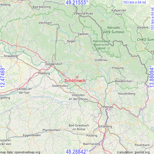
Schöllnach GPS coordinates[2]
48° 45' 14.832" North, 13° 10' 40.116" East
| Map corner | latitude | longitude |
|---|---|---|
| Upper-left | 49.21555°, | 12.47469° |
| Center: | 48.75412°, | 13.17781° |
| Lower-right: | 48.28842°, | 13.88094° |
| Map W x H: | 103.1×103.1 km | = 64.1×64.1mi |
| max Lat: | 55.01917° ⇑85.8% North |
| Schöllnach: | 48.75412° |
| min Lat: | ⇓14.2% South 47.40724° |
| min Long | Schöllnach | max Long |
| 5.92978° | 13.17781° | 14.98853° |
| W 93.5%⇐ | ⇒6.5% E |
Elevation
Elevation of Schöllnach is 381 m = 1250 ft, and this is 131.9 m = 433 ft above average elevation for this country.
| Max E: |
1256 m = 4121 ft | 27.2% |
| Schöllnach | 381 m 1250 ft | |
| Avg. | 249.1 m = 817 ft | |
Min E: |
-5 m = -16 ft | 72.8% |
See also: Germany elevation on elevation.city.
Geographical zone
Schöllnach is located in North temperate zone (between Tropic of Cancer and the Arctic Circle). Distance of this North polar circle is 1980.2 km =1230.4 mi to North.| Distance of | km | miles | from Schöllnach |
|---|---|---|---|
| North Pole | 4586.1 | 2849.7 | to North |
| Arctic Circle | 1980.2 | 1230.4 | to North |
| Tropic Cancer | 2815 | 1749.2 | to South |
| Equator | 5420.9 | 3368.4 | to South |


Nearby cities:
15 places around Schöllnach: (largest is in red/bold)
• Auerbach
7.9 km =4.9 mi,  313°
313°
• Außernzell
3.8 km =2.4 mi,  151°
151°
• Fürstenstein
12.1 km =7.5 mi,  110°
110°
• Grattersdorf
5.8 km =3.6 mi,  342°
342°
• Hengersberg
9.2 km =5.7 mi,  282°
282°
• Hofkirchen
9.5 km =5.9 mi,  206°
206°
• Hunding
9.8 km =6.1 mi,  359°
359°
• Iggensbach
3.7 km =2.3 mi,  224°
224°
• Künzing
11.9 km =7.4 mi, 215°
• Lalling
10.5 km =6.5 mi, 344°
• Niederalteich
11.3 km =7 mi, 276°
• Schöfweg
10.1 km =6.3 mi,  21°
21°
• Thurmansbang
10.2 km =6.3 mi,  82°
82°
• Winzer
8.1 km =5 mi,  244°
244°
• Zenting
7.3 km =4.5 mi,  55°
55°
Sources, notices
• [Note1] Compared only with cities in Germany existing in our database
• [Src1] Map data: © OpenStreetMap contributors (CC-BY-SA)
• [Src2] Other city data from geonames.org with taken over terms of usage.
• [Src3] Geographical zone / Annual Mean Temperature by Robert A. Rohde @ Wikipedia
