Grattersdorf geodata
Grattersdorf (Bavaria) is a seat of a fourth-order administrative division; located in Germany in Europe/Berlin (GMT+2) time zone. With population of 1,424 people, there are 6031 cities with bigger population in this country. Compared to other cities in Germany, 85.3% of cities are located further ↑North; 93.4% of cities are located further ←West and 86% of cities have lower elevation than Grattersdorf. Note1
Administrative division(s):
- Level 1: Bavaria
- Level 2: Lower Bavaria
- Level 3: Landkreis Deggendorf
- Level 4: Grattersdorf


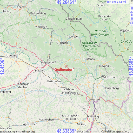
Grattersdorf GPS coordinates[2]
48° 48' 13.104" North, 13° 9' 13.392" East
| Map corner | latitude | longitude |
|---|---|---|
| Upper-left | 49.26461°, | 12.4506° |
| Center: | 48.80364°, | 13.15372° |
| Lower-right: | 48.33839°, | 13.85685° |
| Map W x H: | 103×103 km | = 64×64mi |
| max Lat: | 55.01917° ⇑85.3% North |
| Grattersdorf: | 48.80364° |
| min Lat: | ⇓14.7% South 47.40724° |
| min Long | Grattersdorf | max Long |
| 5.92978° | 13.15372° | 14.98853° |
| W 93.4%⇐ | ⇒6.6% E |
Elevation
Elevation of Grattersdorf is 478 m = 1568 ft, and this is 228.9 m = 751 ft above average elevation for this country.
| Max E: |
1256 m = 4121 ft | 14% |
| Grattersdorf | 478 m 1568 ft | |
| Avg. | 249.1 m = 817 ft | |
Min E: |
-5 m = -16 ft | 86% |
See also: Germany elevation on elevation.city.
Geographical zone
Grattersdorf is located in North temperate zone (between Tropic of Cancer and the Arctic Circle). Distance of this North polar circle is 1974.7 km =1227 mi to North.| Distance of | km | miles | from Grattersdorf |
|---|---|---|---|
| North Pole | 4580.6 | 2846.3 | to North |
| Arctic Circle | 1974.7 | 1227 | to North |
| Tropic Cancer | 2820.5 | 1752.6 | to South |
| Equator | 5426.5 | 3371.9 | to South |


Nearby cities:
15 places around Grattersdorf: (largest is in red/bold)
• Auerbach
4 km =2.5 mi,  269°
269°
• Außernzell
9.6 km =6 mi,  157°
157°
• Hengersberg
8 km =5 mi,  244°
244°
• Hunding
4.6 km =2.9 mi,  21°
21°
• Iggensbach
8.2 km =5.1 mi,  185°
185°
• Innernzell
10.4 km =6.5 mi,  59°
59°
• Kirchberg
10.9 km =6.8 mi,  10°
10°
• Lalling
4.7 km =2.9 mi,  347°
347°
• Niederalteich
10.4 km =6.5 mi,  246°
246°
• Schaufling
8.2 km =5.1 mi,  308°
308°
• Schöfweg
6.7 km =4.2 mi,  54°
54°
• Schöllnach
5.8 km =3.6 mi, 162°
• Thurmansbang
12.6 km =7.8 mi,  109°
109°
• Winzer
10.6 km =6.6 mi,  211°
211°
• Zenting
7.9 km =4.9 mi,  100°
100°
Sources, notices
• [Note1] Compared only with cities in Germany existing in our database
• [Src1] Map data: © OpenStreetMap contributors (CC-BY-SA)
• [Src2] Other city data from geonames.org with taken over terms of usage.
• [Src3] Geographical zone / Annual Mean Temperature by Robert A. Rohde @ Wikipedia
