Künzing geodata
Künzing (Bavaria) is a seat of a fourth-order administrative division; located in Germany in Europe/Berlin (GMT+2) time zone. With population of 3,262 people, there are 3780 cities with bigger population in this country. Compared to other cities in Germany, 86.9% of cities are located further ↑North; 92.9% of cities are located further ←West and 62.9% of cities have lower elevation than Künzing. Note1
Administrative division(s):
- Level 1: Bavaria
- Level 2: Lower Bavaria
- Level 3: Landkreis Deggendorf
- Level 4: Künzing


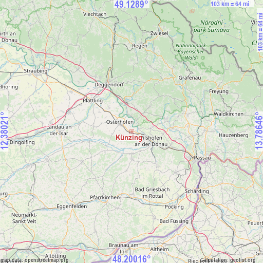
Künzing GPS coordinates[2]
48° 40' 0.012" North, 13° 4' 59.988" East
| Map corner | latitude | longitude |
|---|---|---|
| Upper-left | 49.1289°, | 12.38021° |
| Center: | 48.66667°, | 13.08333° |
| Lower-right: | 48.20016°, | 13.78646° |
| Map W x H: | 103.3×103.3 km | = 64.2×64.2mi |
| max Lat: | 55.01917° ⇑86.9% North |
| Künzing: | 48.66667° |
| min Lat: | ⇓13.1% South 47.40724° |
| min Long | Künzing | max Long |
| 5.92978° | 13.08333° | 14.98853° |
| W 92.9%⇐ | ⇒7.1% E |
Elevation
Elevation of Künzing is 308 m = 1010 ft, and this is 58.9 m = 193 ft above average elevation for this country.
| Max E: |
1256 m = 4121 ft | 37.1% |
| Künzing | 308 m 1010 ft | |
| Avg. | 249.1 m = 817 ft | |
Min E: |
-5 m = -16 ft | 62.9% |
See also: Germany elevation on elevation.city.
Geographical zone
Künzing is located in North temperate zone (between Tropic of Cancer and the Arctic Circle). Distance of this North polar circle is 1989.9 km =1236.5 mi to North.| Distance of | km | miles | from Künzing |
|---|---|---|---|
| North Pole | 4595.8 | 2855.7 | to North |
| Arctic Circle | 1989.9 | 1236.5 | to North |
| Tropic Cancer | 2805.3 | 1743.1 | to South |
| Equator | 5411.2 | 3362.4 | to South |


Nearby cities:
15 places around Künzing: (largest is in red/bold)
• Aidenbach
10.7 km =6.6 mi,  177°
177°
• Aldersbach
8.6 km =5.3 mi, 176°
• Außernzell
10.9 km =6.8 mi,  53°
53°
• Beutelsbach
13.2 km =8.2 mi,  169°
169°
• Buchhofen
12.1 km =7.5 mi,  286°
286°
• Hengersberg
12 km =7.5 mi,  349°
349°
• Hofkirchen
2.9 km =1.8 mi,  64°
64°
• Iggensbach
8.3 km =5.2 mi,  31°
31°
• Moos
13 km =8.1 mi,  316°
316°
• Niederalteich
11.8 km =7.3 mi,  338°
338°
• Osterhofen
5.8 km =3.6 mi,  309°
309°
• Reut
8.8 km =5.5 mi,  160°
160°
• Schöllnach
11.9 km =7.4 mi,  35°
35°
• Vilshofen
9.1 km =5.7 mi,  118°
118°
• Winzer
6.3 km =3.9 mi,  356°
356°
Sources, notices
• [Note1] Compared only with cities in Germany existing in our database
• [Src1] Map data: © OpenStreetMap contributors (CC-BY-SA)
• [Src2] Other city data from geonames.org with taken over terms of usage.
• [Src3] Geographical zone / Annual Mean Temperature by Robert A. Rohde @ Wikipedia
