Außernzell geodata
Außernzell (Bavaria) is a seat of a fourth-order administrative division; located in Germany in Europe/Berlin (GMT+2) time zone. With population of 1,423 people, there are 6034 cities with bigger population in this country. Compared to other cities in Germany, 86.2% of cities are located further ↑North; 93.7% of cities are located further ←West and 72% of cities have lower elevation than Außernzell. Note1
Administrative division(s):
- Level 1: Bavaria
- Level 2: Lower Bavaria
- Level 3: Landkreis Deggendorf
- Level 4: Außernzell


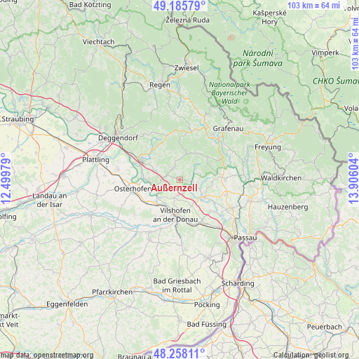
Außernzell GPS coordinates[2]
48° 43' 26.724" North, 13° 12' 10.476" East
| Map corner | latitude | longitude |
|---|---|---|
| Upper-left | 49.18579°, | 12.49979° |
| Center: | 48.72409°, | 13.20291° |
| Lower-right: | 48.25811°, | 13.90604° |
| Map W x H: | 103.1×103.1 km | = 64.1×64.1mi |
| max Lat: | 55.01917° ⇑86.2% North |
| Außernzell: | 48.72409° |
| min Lat: | ⇓13.8% South 47.40724° |
| min Long | Außernzell | max Long |
| 5.92978° | 13.20291° | 14.98853° |
| W 93.7%⇐ | ⇒6.3% E |
Elevation
Elevation of Außernzell is 374 m = 1227 ft, and this is 124.9 m = 410 ft above average elevation for this country.
| Max E: |
1256 m = 4121 ft | 28% |
| Außernzell | 374 m 1227 ft | |
| Avg. | 249.1 m = 817 ft | |
Min E: |
-5 m = -16 ft | 72% |
See also: Germany elevation on elevation.city.
Geographical zone
Außernzell is located in North temperate zone (between Tropic of Cancer and the Arctic Circle). Distance of this North polar circle is 1983.6 km =1232.6 mi to North.| Distance of | km | miles | from Außernzell |
|---|---|---|---|
| North Pole | 4589.5 | 2851.8 | to North |
| Arctic Circle | 1983.6 | 1232.6 | to North |
| Tropic Cancer | 2811.7 | 1747.1 | to South |
| Equator | 5417.6 | 3366.3 | to South |


Nearby cities:
15 places around Außernzell: (largest is in red/bold)
• Aicha vorm Wald
8.6 km =5.3 mi,  128°
128°
• Auerbach
11.6 km =7.2 mi,  319°
319°
• Fürstenstein
9.6 km =6 mi,  94°
94°
• Grattersdorf
9.6 km =6 mi,  337°
337°
• Hengersberg
12.1 km =7.5 mi,  296°
296°
• Hofkirchen
8 km =5 mi,  230°
230°
• Iggensbach
4.5 km =2.8 mi,  278°
278°
• Künzing
10.9 km =6.8 mi, 233°
• Saldenburg
12.5 km =7.8 mi,  64°
64°
• Schöfweg
12.9 km =8 mi,  8°
8°
• Schöllnach
3.8 km =2.4 mi,  331°
331°
• Thurmansbang
9.5 km =5.9 mi, 60°
• Vilshofen
10.8 km =6.7 mi,  184°
184°
• Winzer
9.2 km =5.7 mi,  269°
269°
• Zenting
8.6 km =5.3 mi,  29°
29°
Sources, notices
• [Note1] Compared only with cities in Germany existing in our database
• [Src1] Map data: © OpenStreetMap contributors (CC-BY-SA)
• [Src2] Other city data from geonames.org with taken over terms of usage.
• [Src3] Geographical zone / Annual Mean Temperature by Robert A. Rohde @ Wikipedia
