Schnelldorf geodata
Schnelldorf (Bavaria) is a seat of a fourth-order administrative division; located in Germany in Europe/Berlin (GMT+2) time zone. With population of 3,614 people, there are 3528 cities with bigger population in this country. Compared to other cities in Germany, 80.3% of cities are located further ↑North; 53.1% of cities are located further ←West and 84.9% of cities have lower elevation than Schnelldorf. Note1
Administrative division(s):
- Level 1: Bavaria
- Level 2: Regierungsbezirk Mittelfranken
- Level 3: Landkreis Ansbach
- Level 4: Schnelldorf


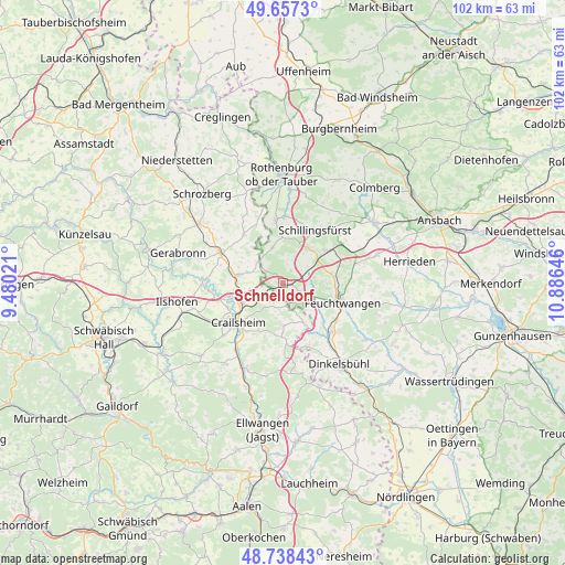
Schnelldorf GPS coordinates[2]
49° 12' 0" North, 10° 10' 59.988" East
| Map corner | latitude | longitude |
|---|---|---|
| Upper-left | 49.6573°, | 9.48021° |
| Center: | 49.2°, | 10.18333° |
| Lower-right: | 48.73843°, | 10.88646° |
| Map W x H: | 102.2×102.2 km | = 63.5×63.5mi |
| max Lat: | 55.01917° ⇑80.3% North |
| Schnelldorf: | 49.2° |
| min Lat: | ⇓19.7% South 47.40724° |
| min Long | Schnelldorf | max Long |
| 5.92978° | 10.18333° | 14.98853° |
| W 53.1%⇐ | ⇒46.9% E |
Elevation
Elevation of Schnelldorf is 468 m = 1535 ft, and this is 218.9 m = 718 ft above average elevation for this country.
| Max E: |
1256 m = 4121 ft | 15.1% |
| Schnelldorf | 468 m 1535 ft | |
| Avg. | 249.1 m = 817 ft | |
Min E: |
-5 m = -16 ft | 84.9% |
See also: Germany elevation on elevation.city.
Geographical zone
Schnelldorf is located in North temperate zone (between Tropic of Cancer and the Arctic Circle). Distance of this North polar circle is 1930.6 km =1199.6 mi to North.| Distance of | km | miles | from Schnelldorf |
|---|---|---|---|
| North Pole | 4536.5 | 2818.8 | to North |
| Arctic Circle | 1930.6 | 1199.6 | to North |
| Tropic Cancer | 2864.6 | 1780 | to South |
| Equator | 5470.5 | 3399.2 | to South |


Nearby cities:
15 places around Schnelldorf: (largest is in red/bold)
• Crailsheim
10.9 km =6.8 mi,  228°
228°
• Diebach
12.1 km =7.5 mi,  2°
2°
• Dombühl
9.5 km =5.9 mi,  51°
51°
• Feuchtwangen
12 km =7.5 mi,  110°
110°
• Gebsattel
16.7 km =10.4 mi, 4°
• Insingen
11.2 km =7 mi,  353°
353°
• Kirchberg an der Jagst
14.6 km =9.1 mi,  270°
270°
• Lichtenau
14.9 km =9.3 mi, 107°
• Rot am See
13.3 km =8.3 mi,  294°
294°
• Satteldorf
8.3 km =5.2 mi,  245°
245°
• Schillingsfürst
11.3 km =7 mi,  30°
30°
• Schopfloch
12.8 km =8 mi,  134°
134°
• Stimpfach
16.8 km =10.4 mi,  203°
203°
• Wallhausen
8.9 km =5.5 mi,  277°
277°
• Wettringen
6.7 km =4.2 mi,  343°
343°
Sources, notices
• [Note1] Compared only with cities in Germany existing in our database
• [Src1] Map data: © OpenStreetMap contributors (CC-BY-SA)
• [Src2] Other city data from geonames.org with taken over terms of usage.
• [Src3] Geographical zone / Annual Mean Temperature by Robert A. Rohde @ Wikipedia
