Feuchtwangen geodata
Feuchtwangen (Bavaria) is a populated place; located in Germany in Europe/Berlin (GMT+2) time zone. With population of 12,267 people, there are 1333 cities with bigger population in this country. Compared to other cities in Germany, 80.9% of cities are located further ↑North; 56.1% of cities are located further ←West and 87.6% of cities have lower elevation than Feuchtwangen. Note1
Administrative division(s):
- Level 1: Bavaria
- Level 2: Regierungsbezirk Mittelfranken
- Level 3: Landkreis Ansbach
- Level 4: Feuchtwangen


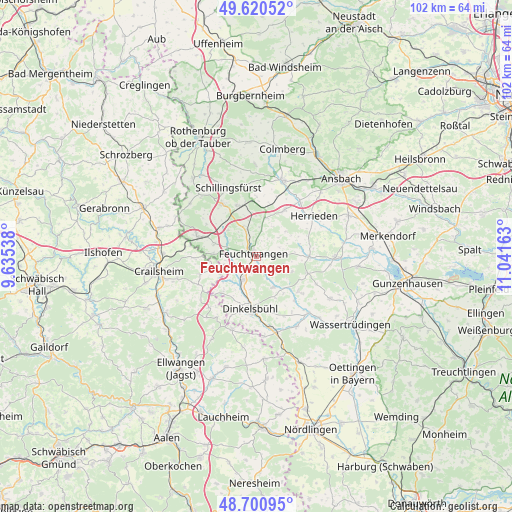
Feuchtwangen GPS coordinates[2]
49° 9' 46.332" North, 10° 20' 18.6" East
| Map corner | latitude | longitude |
|---|---|---|
| Upper-left | 49.62052°, | 9.63538° |
| Center: | 49.16287°, | 10.3385° |
| Lower-right: | 48.70095°, | 11.04163° |
| Map W x H: | 102.2×102.2 km | = 63.5×63.5mi |
| max Lat: | 55.01917° ⇑80.9% North |
| Feuchtwangen: | 49.16287° |
| min Lat: | ⇓19.1% South 47.40724° |
| min Long | Feuchtwangen | max Long |
| 5.92978° | 10.3385° | 14.98853° |
| W 56.1%⇐ | ⇒43.9% E |
Elevation
Elevation of Feuchtwangen is 490 m = 1608 ft, and this is 240.9 m = 790 ft above average elevation for this country.
| Max E: |
1256 m = 4121 ft | 12.4% |
| Feuchtwangen | 490 m 1608 ft | |
| Avg. | 249.1 m = 817 ft | |
Min E: |
-5 m = -16 ft | 87.6% |
See also: Germany elevation on elevation.city.
Geographical zone
Feuchtwangen is located in North temperate zone (between Tropic of Cancer and the Arctic Circle). Distance of this North polar circle is 1934.8 km =1202.2 mi to North.| Distance of | km | miles | from Feuchtwangen |
|---|---|---|---|
| North Pole | 4540.7 | 2821.5 | to North |
| Arctic Circle | 1934.8 | 1202.2 | to North |
| Tropic Cancer | 2860.5 | 1777.4 | to South |
| Equator | 5466.4 | 3396.7 | to South |


Nearby cities:
15 places around Feuchtwangen: (largest is in red/bold)
• Aurach
11.2 km =7 mi,  30°
30°
• Burk
10.7 km =6.6 mi,  107°
107°
• Dentlein am Forst
6.4 km =4 mi, 105°
• Dinkelsbühl
10.5 km =6.5 mi,  187°
187°
• Dombühl
10.8 km =6.7 mi,  339°
339°
• Dürrwangen
7 km =4.3 mi,  151°
151°
• Herrieden
14.6 km =9.1 mi,  55°
55°
• Langfurth
10.8 km =6.7 mi,  129°
129°
• Lichtenau
3 km =1.9 mi,  96°
96°
• Schillingsfürst
14.9 km =9.3 mi, 338°
• Schnelldorf
12 km =7.5 mi,  290°
290°
• Schopfloch
5.3 km =3.3 mi,  204°
204°
• Wieseth
10.5 km =6.5 mi,  87°
87°
• Wittelshofen
15.4 km =9.6 mi,  137°
137°
• Wört
15.5 km =9.6 mi, 198°
Sources, notices
• [Note1] Compared only with cities in Germany existing in our database
• [Src1] Map data: © OpenStreetMap contributors (CC-BY-SA)
• [Src2] Other city data from geonames.org with taken over terms of usage.
• [Src3] Geographical zone / Annual Mean Temperature by Robert A. Rohde @ Wikipedia
