Schillingsfürst geodata
Schillingsfürst (Bavaria) is a populated place; located in Germany in Europe/Berlin (GMT+2) time zone. With population of 2,847 people, there are 4137 cities with bigger population in this country. Compared to other cities in Germany, 78.9% of cities are located further ↑North; 54.6% of cities are located further ←West and 90.1% of cities have lower elevation than Schillingsfürst. Note1
Administrative division(s):
- Level 1: Bavaria
- Level 2: Regierungsbezirk Mittelfranken
- Level 3: Landkreis Ansbach
- Level 4: Schillingsfürst


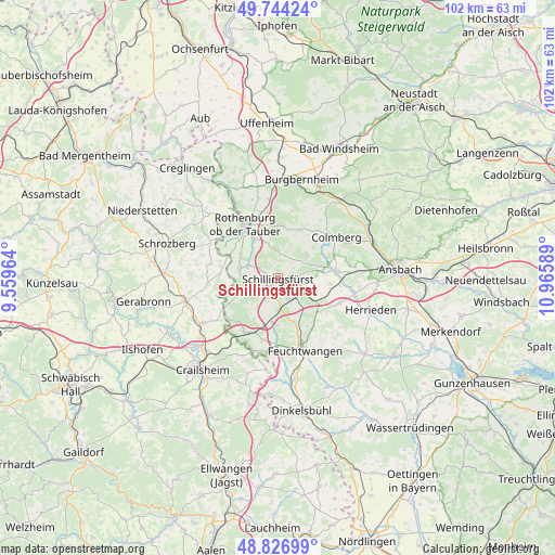
Schillingsfürst GPS coordinates[2]
49° 17' 15.9" North, 10° 15' 45.936" East
| Map corner | latitude | longitude |
|---|---|---|
| Upper-left | 49.74424°, | 9.55964° |
| Center: | 49.28775°, | 10.26276° |
| Lower-right: | 48.82699°, | 10.96589° |
| Map W x H: | 102×102 km | = 63.4×63.4mi |
| max Lat: | 55.01917° ⇑78.9% North |
| Schillingsfürst: | 49.28775° |
| min Lat: | ⇓21.1% South 47.40724° |
| min Long | Schillingsfürs | max Long |
| 5.92978° | 10.26276° | 14.98853° |
| W 54.6%⇐ | ⇒45.4% E |
Elevation
Elevation of Schillingsfürst is 515 m = 1690 ft, and this is 265.9 m = 872 ft above average elevation for this country.
| Max E: |
1256 m = 4121 ft | 9.9% |
| Schillingsfürst | 515 m 1690 ft | |
| Avg. | 249.1 m = 817 ft | |
Min E: |
-5 m = -16 ft | 90.1% |
See also: Germany elevation on elevation.city.
Geographical zone
Schillingsfürst is located in North temperate zone (between Tropic of Cancer and the Arctic Circle). Distance of this North polar circle is 1920.9 km =1193.6 mi to North.| Distance of | km | miles | from Schillingsfürst |
|---|---|---|---|
| North Pole | 4526.8 | 2812.8 | to North |
| Arctic Circle | 1920.9 | 1193.6 | to North |
| Tropic Cancer | 2874.4 | 1786.1 | to South |
| Equator | 5480.3 | 3405.3 | to South |


Nearby cities:
15 places around Schillingsfürst: (largest is in red/bold)
• Aurach
11.9 km =7.4 mi,  110°
110°
• Buch am Wald
7 km =4.3 mi,  47°
47°
• Colmberg
13.1 km =8.1 mi,  55°
55°
• Diebach
5.7 km =3.5 mi,  294°
294°
• Dombühl
4.1 km =2.5 mi,  156°
156°
• Gebsattel
8.3 km =5.2 mi,  326°
326°
• Geslau
9.5 km =5.9 mi,  23°
23°
• Insingen
7.1 km =4.4 mi,  281°
281°
• Leutershausen
10.9 km =6.8 mi,  83°
83°
• Neusitz
9.7 km =6 mi,  343°
343°
• Rothenburg ob der Tauber
11.5 km =7.1 mi, 331°
• Schnelldorf
11.3 km =7 mi,  210°
210°
• Steinsfeld
14.7 km =9.1 mi,  346°
346°
• Wettringen
8.4 km =5.2 mi,  246°
246°
• Windelsbach
12.8 km =8 mi,  12°
12°
Sources, notices
• [Note1] Compared only with cities in Germany existing in our database
• [Src1] Map data: © OpenStreetMap contributors (CC-BY-SA)
• [Src2] Other city data from geonames.org with taken over terms of usage.
• [Src3] Geographical zone / Annual Mean Temperature by Robert A. Rohde @ Wikipedia
