Rot am See geodata
Rot am See (Baden-Württemberg) is a seat of a fourth-order administrative division; located in Germany in Europe/Berlin (GMT+2) time zone. With population of 5,166 people, there are 2762 cities with bigger population in this country. Compared to other cities in Germany, 79.5% of cities are located further ↑North; 50.3% of cities are located further ←West and 78.3% of cities have lower elevation than Rot am See. Note1
Administrative division(s):
- Level 1: Baden-Württemberg
- Level 2: Regierungsbezirk Stuttgart
- Level 3: Landkreis Schwäbisch Hall
- Level 4: Rot am See


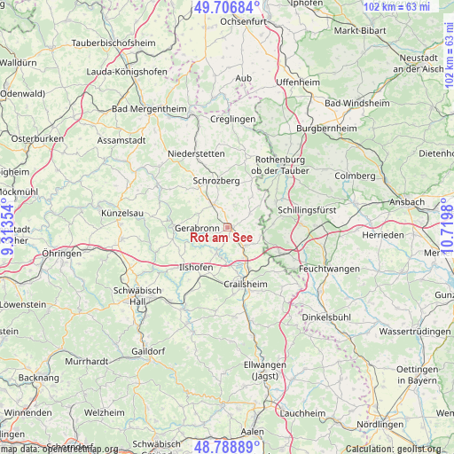
Rot am See GPS coordinates[2]
49° 15' 0" North, 10° 1' 0.012" East
| Map corner | latitude | longitude |
|---|---|---|
| Upper-left | 49.70684°, | 9.31354° |
| Center: | 49.25°, | 10.01667° |
| Lower-right: | 48.78889°, | 10.7198° |
| Map W x H: | 102.1×102.1 km | = 63.4×63.4mi |
| max Lat: | 55.01917° ⇑79.5% North |
| Rot am See: | 49.25° |
| min Lat: | ⇓20.5% South 47.40724° |
| min Long | Rot am See | max Long |
| 5.92978° | 10.01667° | 14.98853° |
| W 50.3%⇐ | ⇒49.7% E |
Elevation
Elevation of Rot am See is 422 m = 1385 ft, and this is 172.9 m = 567 ft above average elevation for this country.
| Max E: |
1256 m = 4121 ft | 21.7% |
| Rot am See | 422 m 1385 ft | |
| Avg. | 249.1 m = 817 ft | |
Min E: |
-5 m = -16 ft | 78.3% |
See also: Germany elevation on elevation.city.
Geographical zone
Rot am See is located in North temperate zone (between Tropic of Cancer and the Arctic Circle). Distance of this North polar circle is 1925.1 km =1196.2 mi to North.| Distance of | km | miles | from Rot am See |
|---|---|---|---|
| North Pole | 4531 | 2815.4 | to North |
| Arctic Circle | 1925.1 | 1196.2 | to North |
| Tropic Cancer | 2870.2 | 1783.5 | to South |
| Equator | 5476.1 | 3402.7 | to South |


Nearby cities:
15 places around Rot am See: (largest is in red/bold)
• Blaufelden
6.2 km =3.9 mi,  329°
329°
• Braunsbach
17.4 km =10.8 mi,  251°
251°
• Crailsheim
13.5 km =8.4 mi,  162°
162°
• Diebach
14.3 km =8.9 mi,  62°
62°
• Gebsattel
17.3 km =10.7 mi,  50°
50°
• Ilshofen
11.4 km =7.1 mi,  218°
218°
• Insingen
12.2 km =7.6 mi, 62°
• Kirchberg an der Jagst
6 km =3.7 mi,  204°
204°
• Langenburg
11.6 km =7.2 mi,  272°
272°
• Satteldorf
10 km =6.2 mi,  152°
152°
• Schnelldorf
13.3 km =8.3 mi,  114°
114°
• Schrozberg
10.9 km =6.8 mi,  345°
345°
• Wallhausen
5.5 km =3.4 mi,  143°
143°
• Wettringen
10.2 km =6.3 mi,  85°
85°
• Wolpertshausen
15.5 km =9.6 mi,  233°
233°
Sources, notices
• [Note1] Compared only with cities in Germany existing in our database
• [Src1] Map data: © OpenStreetMap contributors (CC-BY-SA)
• [Src2] Other city data from geonames.org with taken over terms of usage.
• [Src3] Geographical zone / Annual Mean Temperature by Robert A. Rohde @ Wikipedia
