Schnaittenbach geodata
Schnaittenbach (Bavaria) is a populated place; located in Germany in Europe/Berlin (GMT+2) time zone. With population of 4,375 people, there are 3104 cities with bigger population in this country. Compared to other cities in Germany, 74.9% of cities are located further ↑North; 81.8% of cities are located further ←West and 76.4% of cities have lower elevation than Schnaittenbach. Note1
Administrative division(s):
- Level 1: Bavaria
- Level 2: Upper Palatinate
- Level 3: Landkreis Amberg-Sulzbach
- Level 4: Schnaittenbach


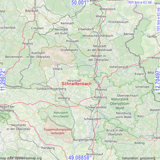
Schnaittenbach GPS coordinates[2]
49° 32' 48.912" North, 12° 0' 6.624" East
| Map corner | latitude | longitude |
|---|---|---|
| Upper-left | 50.001°, | 11.29872° |
| Center: | 49.54692°, | 12.00184° |
| Lower-right: | 49.08858°, | 12.70497° |
| Map W x H: | 101.5×101.4 km | = 63.1×63mi |
| max Lat: | 55.01917° ⇑74.9% North |
| Schnaittenbach: | 49.54692° |
| min Lat: | ⇓25.1% South 47.40724° |
| min Long | Schnaittenbach | max Long |
| 5.92978° | 12.00184° | 14.98853° |
| W 81.8%⇐ | ⇒18.2% E |
Elevation
Elevation of Schnaittenbach is 408 m = 1339 ft, and this is 158.9 m = 521 ft above average elevation for this country.
| Max E: |
1256 m = 4121 ft | 23.6% |
| Schnaittenbach | 408 m 1339 ft | |
| Avg. | 249.1 m = 817 ft | |
Min E: |
-5 m = -16 ft | 76.4% |
See also: Germany elevation on elevation.city.
Geographical zone
Schnaittenbach is located in North temperate zone (between Tropic of Cancer and the Arctic Circle). Distance of this North polar circle is 1892.1 km =1175.7 mi to North.| Distance of | km | miles | from Schnaittenbach |
|---|---|---|---|
| North Pole | 4498 | 2794.9 | to North |
| Arctic Circle | 1892.1 | 1175.7 | to North |
| Tropic Cancer | 2903.2 | 1804 | to South |
| Equator | 5509.1 | 3423.2 | to South |


Nearby cities:
15 places around Schnaittenbach: (largest is in red/bold)
• Amberg
15.3 km =9.5 mi,  220°
220°
• Etzenricht
11.9 km =7.4 mi,  36°
36°
• Freihung
10.7 km =6.6 mi,  320°
320°
• Freudenberg
7.2 km =4.5 mi,  190°
190°
• Gebenbach
9.4 km =5.8 mi,  263°
263°
• Hahnbach
14.4 km =8.9 mi, 264°
• Hirschau
4 km =2.5 mi,  265°
265°
• Kohlberg
5.1 km =3.2 mi,  14°
14°
• Luhe-Wildenau
11.4 km =7.1 mi,  68°
68°
• Mantel
12.2 km =7.6 mi, 13°
• Pfreimd
14.3 km =8.9 mi,  115°
115°
• Pirk
15.3 km =9.5 mi,  51°
51°
• Schmidgaden
15.2 km =9.4 mi,  154°
154°
• Weiherhammer
10.7 km =6.6 mi,  25°
25°
• Wernberg-Köblitz
11.5 km =7.1 mi,  94°
94°
Sources, notices
• [Note1] Compared only with cities in Germany existing in our database
• [Src1] Map data: © OpenStreetMap contributors (CC-BY-SA)
• [Src2] Other city data from geonames.org with taken over terms of usage.
• [Src3] Geographical zone / Annual Mean Temperature by Robert A. Rohde @ Wikipedia
