Schmidgaden geodata
Schmidgaden (Bavaria) is a seat of a fourth-order administrative division; located in Germany in Europe/Berlin (GMT+2) time zone. With population of 2,881 people, there are 4116 cities with bigger population in this country. Compared to other cities in Germany, 76.9% of cities are located further ↑North; 83.1% of cities are located further ←West and 73% of cities have lower elevation than Schmidgaden. Note1
Administrative division(s):
- Level 1: Bavaria
- Level 2: Upper Palatinate
- Level 3: Landkreis Schwandorf
- Level 4: Schmidgaden


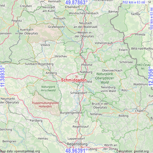
Schmidgaden GPS coordinates[2]
49° 25' 24.24" North, 12° 5' 32.892" East
| Map corner | latitude | longitude |
|---|---|---|
| Upper-left | 49.87863°, | 11.38935° |
| Center: | 49.4234°, | 12.09247° |
| Lower-right: | 48.96391°, | 12.7956° |
| Map W x H: | 101.7×101.7 km | = 63.2×63.2mi |
| max Lat: | 55.01917° ⇑76.9% North |
| Schmidgaden: | 49.4234° |
| min Lat: | ⇓23.1% South 47.40724° |
| min Long | Schmidgaden | max Long |
| 5.92978° | 12.09247° | 14.98853° |
| W 83.1%⇐ | ⇒16.9% E |
Elevation
Elevation of Schmidgaden is 382 m = 1253 ft, and this is 132.9 m = 436 ft above average elevation for this country.
| Max E: |
1256 m = 4121 ft | 27% |
| Schmidgaden | 382 m 1253 ft | |
| Avg. | 249.1 m = 817 ft | |
Min E: |
-5 m = -16 ft | 73% |
See also: Germany elevation on elevation.city.
Geographical zone
Schmidgaden is located in North temperate zone (between Tropic of Cancer and the Arctic Circle). Distance of this North polar circle is 1905.8 km =1184.2 mi to North.| Distance of | km | miles | from Schmidgaden |
|---|---|---|---|
| North Pole | 4511.7 | 2803.4 | to North |
| Arctic Circle | 1905.8 | 1184.2 | to North |
| Tropic Cancer | 2889.4 | 1795.4 | to South |
| Equator | 5495.4 | 3414.7 | to South |


Nearby cities:
15 places around Schmidgaden: (largest is in red/bold)
• Altendorf
13.8 km =8.6 mi,  98°
98°
• Breitenbrunn
8.4 km =5.2 mi,  218°
218°
• Ebermannsdorf
11.8 km =7.3 mi,  253°
253°
• Ensdorf
14.6 km =9.1 mi,  230°
230°
• Freudenberg
10.3 km =6.4 mi,  310°
310°
• Guteneck
14.1 km =8.8 mi,  77°
77°
• Kümmersbruck
14.8 km =9.2 mi,  268°
268°
• Nabburg
7.2 km =4.5 mi,  62°
62°
• Pfreimd
9.9 km =6.2 mi,  40°
40°
• Schnaittenbach
15.2 km =9.4 mi,  334°
334°
• Schwandorf in Bayern
11 km =6.8 mi,  173°
173°
• Schwarzenfeld
5 km =3.1 mi,  142°
142°
• Stulln
3 km =1.9 mi, 104°
• Wackersdorf
13.6 km =8.5 mi,  150°
150°
• Wernberg-Köblitz
13.8 km =8.6 mi,  21°
21°
Sources, notices
• [Note1] Compared only with cities in Germany existing in our database
• [Src1] Map data: © OpenStreetMap contributors (CC-BY-SA)
• [Src2] Other city data from geonames.org with taken over terms of usage.
• [Src3] Geographical zone / Annual Mean Temperature by Robert A. Rohde @ Wikipedia
