Freihung geodata
Freihung (Bavaria) is a populated place; located in Germany in Europe/Berlin (GMT+2) time zone. With population of 2,610 people, there are 4321 cities with bigger population in this country. Compared to other cities in Germany, 73.2% of cities are located further ↑North; 80.4% of cities are located further ←West and 78% of cities have lower elevation than Freihung. Note1
Administrative division(s):
- Level 1: Bavaria
- Level 2: Upper Palatinate
- Level 3: Landkreis Amberg-Sulzbach
- Level 4: Freihung, Markt


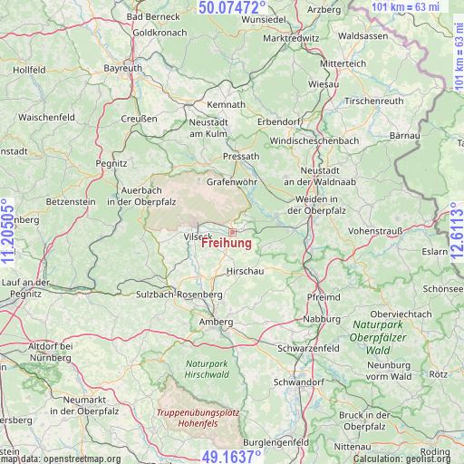
Freihung GPS coordinates[2]
49° 37' 16.824" North, 11° 54' 29.412" East
| Map corner | latitude | longitude |
|---|---|---|
| Upper-left | 50.07472°, | 11.20505° |
| Center: | 49.62134°, | 11.90817° |
| Lower-right: | 49.1637°, | 12.6113° |
| Map W x H: | 101.3×101.3 km | = 62.9×62.9mi |
| max Lat: | 55.01917° ⇑73.2% North |
| Freihung: | 49.62134° |
| min Lat: | ⇓26.8% South 47.40724° |
| min Long | Freihung | max Long |
| 5.92978° | 11.90817° | 14.98853° |
| W 80.4%⇐ | ⇒19.6% E |
Elevation
Elevation of Freihung is 419 m = 1375 ft, and this is 169.9 m = 557 ft above average elevation for this country.
| Max E: |
1256 m = 4121 ft | 22% |
| Freihung | 419 m 1375 ft | |
| Avg. | 249.1 m = 817 ft | |
Min E: |
-5 m = -16 ft | 78% |
See also: Germany elevation on elevation.city.
Geographical zone
Freihung is located in North temperate zone (between Tropic of Cancer and the Arctic Circle). Distance of this North polar circle is 1883.8 km =1170.5 mi to North.| Distance of | km | miles | from Freihung |
|---|---|---|---|
| North Pole | 4489.7 | 2789.8 | to North |
| Arctic Circle | 1883.8 | 1170.5 | to North |
| Tropic Cancer | 2911.5 | 1809.1 | to South |
| Equator | 5517.4 | 3428.4 | to South |


Nearby cities:
15 places around Freihung: (largest is in red/bold)
• Edelsfeld
16.1 km =10 mi,  251°
251°
• Etzenricht
13.9 km =8.6 mi,  84°
84°
• Freudenberg
16.3 km =10.1 mi,  160°
160°
• Gebenbach
9.7 km =6 mi,  195°
195°
• Grafenwöhr
10.7 km =6.6 mi,  359°
359°
• Hahnbach
12.3 km =7.6 mi,  217°
217°
• Hirschau
9 km =5.6 mi, 162°
• Kohlberg
8.7 km =5.4 mi,  112°
112°
• Mantel
10.2 km =6.3 mi,  69°
69°
• Parkstein
16.6 km =10.3 mi,  43°
43°
• Pressath
16.5 km =10.3 mi,  7°
7°
• Schnaittenbach
10.7 km =6.6 mi,  140°
140°
• Schwarzenbach
13.2 km =8.2 mi,  29°
29°
• Vilseck
7.6 km =4.7 mi,  264°
264°
• Weiherhammer
11.5 km =7.1 mi, 83°
Sources, notices
• [Note1] Compared only with cities in Germany existing in our database
• [Src1] Map data: © OpenStreetMap contributors (CC-BY-SA)
• [Src2] Other city data from geonames.org with taken over terms of usage.
• [Src3] Geographical zone / Annual Mean Temperature by Robert A. Rohde @ Wikipedia
