Hirschau geodata
Hirschau (Bavaria) is a populated place; located in Germany in Europe/Berlin (GMT+2) time zone. With population of 6,258 people, there are 2382 cities with bigger population in this country. Compared to other cities in Germany, 74.9% of cities are located further ↑North; 81% of cities are located further ←West and 77.2% of cities have lower elevation than Hirschau. Note1
Administrative division(s):
- Level 1: Bavaria
- Level 2: Upper Palatinate
- Level 3: Landkreis Amberg-Sulzbach
- Level 4: Hirschau


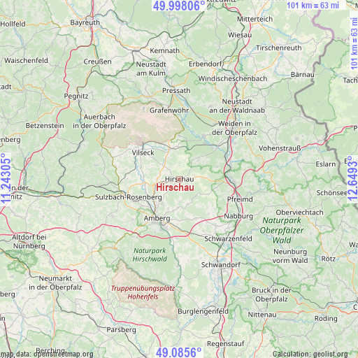
Hirschau GPS coordinates[2]
49° 32' 38.256" North, 11° 56' 46.212" East
| Map corner | latitude | longitude |
|---|---|---|
| Upper-left | 49.99806°, | 11.24305° |
| Center: | 49.54396°, | 11.94617° |
| Lower-right: | 49.0856°, | 12.6493° |
| Map W x H: | 101.5×101.5 km | = 63.1×63.1mi |
| max Lat: | 55.01917° ⇑74.9% North |
| Hirschau: | 49.54396° |
| min Lat: | ⇓25.1% South 47.40724° |
| min Long | Hirschau | max Long |
| 5.92978° | 11.94617° | 14.98853° |
| W 81%⇐ | ⇒19% E |
Elevation
Elevation of Hirschau is 414 m = 1358 ft, and this is 164.9 m = 541 ft above average elevation for this country.
| Max E: |
1256 m = 4121 ft | 22.8% |
| Hirschau | 414 m 1358 ft | |
| Avg. | 249.1 m = 817 ft | |
Min E: |
-5 m = -16 ft | 77.2% |
See also: Germany elevation on elevation.city.
Geographical zone
Hirschau is located in North temperate zone (between Tropic of Cancer and the Arctic Circle). Distance of this North polar circle is 1892.4 km =1175.9 mi to North.| Distance of | km | miles | from Hirschau |
|---|---|---|---|
| North Pole | 4498.3 | 2795.1 | to North |
| Arctic Circle | 1892.4 | 1175.9 | to North |
| Tropic Cancer | 2902.9 | 1803.8 | to South |
| Equator | 5508.8 | 3423 | to South |


Nearby cities:
15 places around Hirschau: (largest is in red/bold)
• Amberg
12.8 km =8 mi,  208°
208°
• Etzenricht
14.9 km =9.3 mi,  48°
48°
• Freihung
9 km =5.6 mi,  342°
342°
• Freudenberg
7.3 km =4.5 mi,  158°
158°
• Gebenbach
5.4 km =3.4 mi,  262°
262°
• Hahnbach
10.4 km =6.5 mi, 263°
• Kohlberg
7.5 km =4.7 mi, 45°
• Kümmersbruck
14.5 km =9 mi,  196°
196°
• Luhe-Wildenau
15.3 km =9.5 mi,  73°
73°
• Mantel
14 km =8.7 mi,  29°
29°
• Poppenricht
13.1 km =8.1 mi,  234°
234°
• Schnaittenbach
4 km =2.5 mi,  85°
85°
• Sulzbach-Rosenberg
15.2 km =9.4 mi,  251°
251°
• Vilseck
13 km =8.1 mi,  307°
307°
• Weiherhammer
13.2 km =8.2 mi,  41°
41°
Sources, notices
• [Note1] Compared only with cities in Germany existing in our database
• [Src1] Map data: © OpenStreetMap contributors (CC-BY-SA)
• [Src2] Other city data from geonames.org with taken over terms of usage.
• [Src3] Geographical zone / Annual Mean Temperature by Robert A. Rohde @ Wikipedia
