Schnackenburg geodata
Schnackenburg (Lower Saxony) is a populated place; located in Germany in Europe/Berlin (GMT+2) time zone. With population of 666 people, there are 8492 cities with bigger population in this country. Compared to other cities in Germany, 82% of cities are located further ↓South; 75.2% of cities are located further ←West and 90.9% of cities have higher elevation than Schnackenburg. Note1
Administrative division(s):
- Level 1: Lower Saxony
- Level 3: Landkreis Lüchow-Dannenberg
- Level 4: Schnackenburg


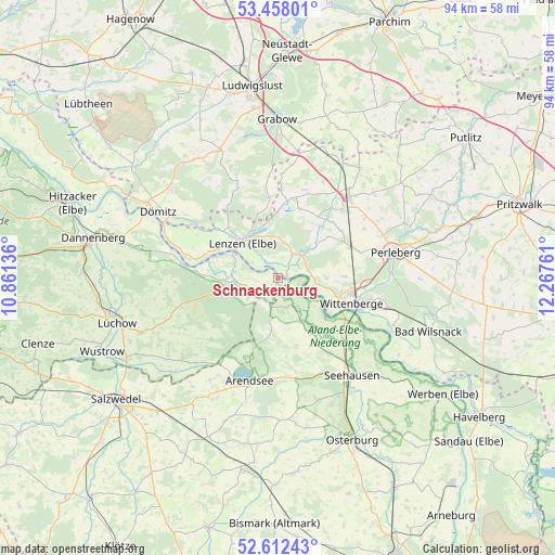
Schnackenburg GPS coordinates[2]
53° 2' 14.244" North, 11° 33' 52.128" East
| Map corner | latitude | longitude |
|---|---|---|
| Upper-left | 53.45801°, | 10.86136° |
| Center: | 53.03729°, | 11.56448° |
| Lower-right: | 52.61243°, | 12.26761° |
| Map W x H: | 94×94 km | = 58.4×58.4mi |
| max Lat: | 55.01917° ⇑18% North |
| Schnackenburg: | 53.03729° |
| min Lat: | ⇓82% South 47.40724° |
| min Long | Schnackenburg | max Long |
| 5.92978° | 11.56448° | 14.98853° |
| W 75.2%⇐ | ⇒24.8% E |
Elevation
Elevation of Schnackenburg is 19 m = 62 ft, and this is 230.1 m = 755 ft below average elevation for this country.
| Max E: |
1256 m = 4121 ft | 90.9% |
| Avg. | 249.1 m = 817 ft | |
| Schnackenburg | 19 m = 62 ft | |
Min E: |
-5 m = -16 ft | 9.1% |
See also: Germany elevation on elevation.city.
Geographical zone
Schnackenburg is located in North temperate zone (between Tropic of Cancer and the Arctic Circle). Distance of this North polar circle is 1504 km =934.5 mi to North.| Distance of | km | miles | from Schnackenburg |
|---|---|---|---|
| North Pole | 4109.9 | 2553.8 | to North |
| Arctic Circle | 1504 | 934.5 | to North |
| Tropic Cancer | 3291.3 | 2045.1 | to South |
| Equator | 5897.2 | 3664.3 | to South |


Nearby cities:
15 places around Schnackenburg: (largest is in red/bold)
• Beuster
18.4 km =11.4 mi,  126°
126°
• Breese
16.3 km =10.1 mi,  104°
104°
• Cumlosen
6.8 km =4.2 mi,  93°
93°
• Gartow
7 km =4.3 mi,  258°
258°
• Gorleben
13.9 km =8.6 mi,  275°
275°
• Groß Garz
12 km =7.5 mi,  164°
164°
• Karstädt
18.3 km =11.4 mi,  40°
40°
• Krüden
15.5 km =9.6 mi,  144°
144°
• Lanz
4.7 km =2.9 mi,  29°
29°
• Lenzen
8.5 km =5.3 mi,  315°
315°
• Luftkurort Arendsee
18.2 km =11.3 mi,  196°
196°
• Prezelle
13.5 km =8.4 mi,  234°
234°
• Trebel
17.1 km =10.6 mi, 255°
• Weisen
14.9 km =9.3 mi, 95°
• Wittenberge
12.9 km =8 mi,  105°
105°
Sources, notices
• [Note1] Compared only with cities in Germany existing in our database
• [Src1] Map data: © OpenStreetMap contributors (CC-BY-SA)
• [Src2] Other city data from geonames.org with taken over terms of usage.
• [Src3] Geographical zone / Annual Mean Temperature by Robert A. Rohde @ Wikipedia
