Lanz geodata
Lanz (Brandenburg) is a seat of a fourth-order administrative division; located in Germany in Europe/Berlin (GMT+2) time zone. With population of 902 people, there are 7516 cities with bigger population in this country. Compared to other cities in Germany, 82.2% of cities are located further ↓South; 75.7% of cities are located further ←West and 89.7% of cities have higher elevation than Lanz. Note1


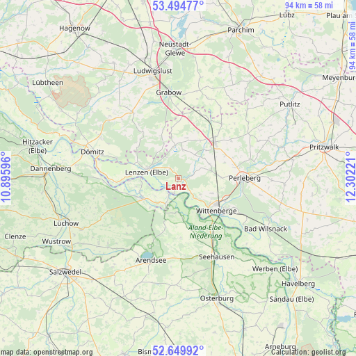
Lanz GPS coordinates[2]
53° 4' 27.912" North, 11° 35' 56.688" East
| Map corner | latitude | longitude |
|---|---|---|
| Upper-left | 53.49477°, | 10.89596° |
| Center: | 53.07442°, | 11.59908° |
| Lower-right: | 52.64992°, | 12.30221° |
| Map W x H: | 93.9×93.9 km | = 58.3×58.3mi |
| max Lat: | 55.01917° ⇑17.8% North |
| Lanz: | 53.07442° |
| min Lat: | ⇓82.2% South 47.40724° |
| min Long | Lanz | max Long |
| 5.92978° | 11.59908° | 14.98853° |
| W 75.7%⇐ | ⇒24.3% E |
Elevation
Elevation of Lanz is 22 m = 72 ft, and this is 227.1 m = 745 ft below average elevation for this country.
| Max E: |
1256 m = 4121 ft | 89.7% |
| Avg. | 249.1 m = 817 ft | |
| Lanz | 22 m = 72 ft | |
Min E: |
-5 m = -16 ft | 10.3% |
See also: Germany elevation on elevation.city.
Geographical zone
Lanz is located in North temperate zone (between Tropic of Cancer and the Arctic Circle). Distance of this North polar circle is 1499.9 km =932 mi to North.| Distance of | km | miles | from Lanz |
|---|---|---|---|
| North Pole | 4105.7 | 2551.2 | to North |
| Arctic Circle | 1499.9 | 932 | to North |
| Tropic Cancer | 3295.4 | 2047.7 | to South |
| Equator | 5901.3 | 3666.9 | to South |


Nearby cities:
15 places around Lanz: (largest is in red/bold)
• Beuster
19.5 km =12.1 mi,  140°
140°
• Breese
15.8 km =9.8 mi,  121°
121°
• Cumlosen
6.4 km =4 mi, 135°
• Gartow
10.7 km =6.6 mi,  238°
238°
• Gorleben
16.4 km =10.2 mi,  259°
259°
• Groß Garz
15.7 km =9.8 mi,  177°
177°
• Karstädt
13.7 km =8.5 mi,  44°
44°
• Krüden
18.1 km =11.2 mi,  158°
158°
• Lenzen
8.5 km =5.3 mi,  283°
283°
• Perleberg
17.3 km =10.7 mi,  89°
89°
• Prezelle
17.9 km =11.1 mi,  228°
228°
• Schnackenburg
4.7 km =2.9 mi,  209°
209°
• Trebel
20.6 km =12.8 mi,  246°
246°
• Weisen
13.7 km =8.5 mi,  113°
113°
• Wittenberge
12.7 km =7.9 mi,  127°
127°
Sources, notices
• [Note1] Compared only with cities in Germany existing in our database
• [Src1] Map data: © OpenStreetMap contributors (CC-BY-SA)
• [Src2] Other city data from geonames.org with taken over terms of usage.
• [Src3] Geographical zone / Annual Mean Temperature by Robert A. Rohde @ Wikipedia
