Schmalfeld geodata
Schmalfeld (Schleswig-Holstein) is a seat of a fourth-order administrative division; located in Germany in Europe/Berlin (GMT+2) time zone. With population of 1,885 people, there are 5228 cities with bigger population in this country. Compared to other cities in Germany, 91% of cities are located further ↓South; 50.6% of cities are located further →East and 90.9% of cities have higher elevation than Schmalfeld. Note1


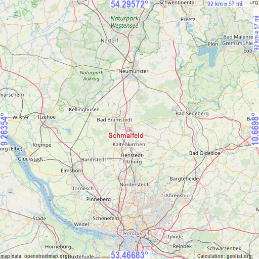
Schmalfeld GPS coordinates[2]
53° 52' 59.988" North, 9° 58' 0.012" East
| Map corner | latitude | longitude |
|---|---|---|
| Upper-left | 54.29572°, | 9.26354° |
| Center: | 53.88333°, | 9.96667° |
| Lower-right: | 53.46683°, | 10.6698° |
| Map W x H: | 92.2×92.2 km | = 57.3×57.3mi |
| max Lat: | 55.01917° ⇑9% North |
| Schmalfeld: | 53.88333° |
| min Lat: | ⇓91% South 47.40724° |
| min Long | Schmalfeld | max Long |
| 5.92978° | 9.96667° | 14.98853° |
| W 49.4%⇐ | ⇒50.6% E |
Elevation
Elevation of Schmalfeld is 19 m = 62 ft, and this is 230.1 m = 755 ft below average elevation for this country.
| Max E: |
1256 m = 4121 ft | 90.9% |
| Avg. | 249.1 m = 817 ft | |
| Schmalfeld | 19 m = 62 ft | |
Min E: |
-5 m = -16 ft | 9.1% |
See also: Germany elevation on elevation.city.
Geographical zone
Schmalfeld is located in North temperate zone (between Tropic of Cancer and the Arctic Circle). Distance of this North polar circle is 1409.9 km =876.1 mi to North.| Distance of | km | miles | from Schmalfeld |
|---|---|---|---|
| North Pole | 4015.8 | 2495.3 | to North |
| Arctic Circle | 1409.9 | 876.1 | to North |
| Tropic Cancer | 3385.3 | 2103.5 | to South |
| Equator | 5991.3 | 3722.8 | to South |


Nearby cities:
15 places around Schmalfeld: (largest is in red/bold)
• Bad Bramstedt
6.7 km =4.2 mi,  305°
305°
• Bimöhlen
5.7 km =3.5 mi,  348°
348°
• Fuhlendorf
8.5 km =5.3 mi,  322°
322°
• Hartenholm
6.3 km =3.9 mi,  74°
74°
• Hasenmoor
2.2 km =1.4 mi,  30°
30°
• Hüttblek
8.6 km =5.3 mi,  130°
130°
• Kaltenkirchen
5.6 km =3.5 mi,  185°
185°
• Kampen
3.7 km =2.3 mi,  213°
213°
• Kattendorf
5.8 km =3.6 mi,  140°
140°
• Kisdorf
8.1 km =5 mi,  156°
156°
• Lentföhrden
5.8 km =3.6 mi,  251°
251°
• Nützen
3.8 km =2.4 mi,  240°
240°
• Oersdorf
5.2 km =3.2 mi, 161°
• Struvenhütten
5.8 km =3.6 mi,  108°
108°
• Winsen
6.5 km =4 mi,  149°
149°
Sources, notices
• [Note1] Compared only with cities in Germany existing in our database
• [Src1] Map data: © OpenStreetMap contributors (CC-BY-SA)
• [Src2] Other city data from geonames.org with taken over terms of usage.
• [Src3] Geographical zone / Annual Mean Temperature by Robert A. Rohde @ Wikipedia
