Kampen geodata
Kampen (Schleswig-Holstein) is a populated place; located in Germany in Europe/Berlin (GMT+2) time zone. With population of 637 people, there are 8614 cities with bigger population in this country. Compared to other cities in Germany, 90.7% of cities are located further ↓South; 50.9% of cities are located further →East and 91.2% of cities have higher elevation than Kampen. Note1


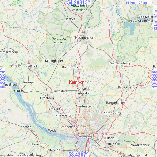
Kampen GPS coordinates[2]
53° 51' 19.728" North, 9° 56' 8.412" East
| Map corner | latitude | longitude |
|---|---|---|
| Upper-left | 54.26815°, | 9.23254° |
| Center: | 53.85548°, | 9.93567° |
| Lower-right: | 53.4387°, | 10.6388° |
| Map W x H: | 92.2×92.2 km | = 57.3×57.3mi |
| max Lat: | 55.01917° ⇑9.3% North |
| Kampen: | 53.85548° |
| min Lat: | ⇓90.7% South 47.40724° |
| min Long | Kampen | max Long |
| 5.92978° | 9.93567° | 14.98853° |
| W 49.1%⇐ | ⇒50.9% E |
Elevation
Elevation of Kampen is 18 m = 59 ft, and this is 231.1 m = 758 ft below average elevation for this country.
| Max E: |
1256 m = 4121 ft | 91.2% |
| Avg. | 249.1 m = 817 ft | |
| Kampen | 18 m = 59 ft | |
Min E: |
-5 m = -16 ft | 8.8% |
See also: Germany elevation on elevation.city.
Geographical zone
Kampen is located in North temperate zone (between Tropic of Cancer and the Arctic Circle). Distance of this North polar circle is 1413 km =878 mi to North.| Distance of | km | miles | from Kampen |
|---|---|---|---|
| North Pole | 4018.9 | 2497.2 | to North |
| Arctic Circle | 1413 | 878 | to North |
| Tropic Cancer | 3382.2 | 2101.6 | to South |
| Equator | 5988.2 | 3720.9 | to South |


Nearby cities:
15 places around Kampen: (largest is in red/bold)
• Alveslohe
8.1 km =5 mi,  188°
188°
• Bad Bramstedt
7.8 km =4.8 mi,  334°
334°
• Hasenmoor
5.9 km =3.7 mi,  32°
32°
• Heidmoor
6.1 km =3.8 mi,  246°
246°
• Henstedt-Ulzburg
6.2 km =3.9 mi,  155°
155°
• Kaltenkirchen
2.9 km =1.8 mi,  149°
149°
• Kattendorf
5.9 km =3.7 mi,  103°
103°
• Kisdorf
6.8 km =4.2 mi,  129°
129°
• Lentföhrden
3.7 km =2.3 mi,  289°
289°
• Nützen
1.8 km =1.1 mi,  314°
314°
• Oersdorf
4.1 km =2.5 mi,  116°
116°
• Schmalfeld
3.7 km =2.3 mi, 33°
• Struvenhütten
7.6 km =4.7 mi,  80°
80°
• Weddelbrook
8.3 km =5.2 mi, 306°
• Winsen
5.9 km =3.7 mi,  114°
114°
Sources, notices
• [Note1] Compared only with cities in Germany existing in our database
• [Src1] Map data: © OpenStreetMap contributors (CC-BY-SA)
• [Src2] Other city data from geonames.org with taken over terms of usage.
• [Src3] Geographical zone / Annual Mean Temperature by Robert A. Rohde @ Wikipedia
