Kattendorf geodata
Kattendorf (Schleswig-Holstein) is a seat of a fourth-order administrative division; located in Germany in Europe/Berlin (GMT+2) time zone. With population of 914 people, there are 7476 cities with bigger population in this country. Compared to other cities in Germany, 90.5% of cities are located further ↓South; 50.5% of cities are located further ←West and 78.3% of cities have higher elevation than Kattendorf. Note1


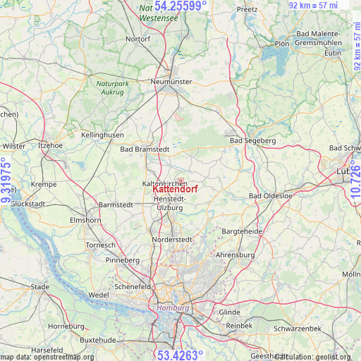
Kattendorf GPS coordinates[2]
53° 50' 35.52" North, 10° 1' 22.332" East
| Map corner | latitude | longitude |
|---|---|---|
| Upper-left | 54.25599°, | 9.31975° |
| Center: | 53.8432°, | 10.02287° |
| Lower-right: | 53.4263°, | 10.726° |
| Map W x H: | 92.3×92.3 km | = 57.4×57.4mi |
| max Lat: | 55.01917° ⇑9.5% North |
| Kattendorf: | 53.8432° |
| min Lat: | ⇓90.5% South 47.40724° |
| min Long | Kattendorf | max Long |
| 5.92978° | 10.02287° | 14.98853° |
| W 50.5%⇐ | ⇒49.5% E |
Elevation
Elevation of Kattendorf is 52 m = 171 ft, and this is 197.1 m = 647 ft below average elevation for this country.
| Max E: |
1256 m = 4121 ft | 78.3% |
| Avg. | 249.1 m = 817 ft | |
| Kattendorf | 52 m = 171 ft | |
Min E: |
-5 m = -16 ft | 21.7% |
See also: Germany elevation on elevation.city.
Geographical zone
Kattendorf is located in North temperate zone (between Tropic of Cancer and the Arctic Circle). Distance of this North polar circle is 1414.4 km =878.9 mi to North.| Distance of | km | miles | from Kattendorf |
|---|---|---|---|
| North Pole | 4020.3 | 2498.1 | to North |
| Arctic Circle | 1414.4 | 878.9 | to North |
| Tropic Cancer | 3380.9 | 2100.8 | to South |
| Equator | 5986.8 | 3720 | to South |


Nearby cities:
15 places around Kattendorf: (largest is in red/bold)
• Hartenholm
6.6 km =4.1 mi,  21°
21°
• Hasenmoor
6.8 km =4.2 mi,  337°
337°
• Henstedt-Ulzburg
5.3 km =3.3 mi,  216°
216°
• Hüttblek
3.1 km =1.9 mi,  110°
110°
• Kaltenkirchen
4.4 km =2.7 mi,  254°
254°
• Kampen
5.9 km =3.7 mi,  283°
283°
• Kisdorf
3 km =1.9 mi,  187°
187°
• Nahe
8.7 km =5.4 mi,  123°
123°
• Nützen
7.4 km =4.6 mi,  290°
290°
• Oersdorf
2.1 km =1.3 mi,  257°
257°
• Schmalfeld
5.8 km =3.6 mi,  320°
320°
• Sievershütten
5.9 km =3.7 mi,  90°
90°
• Struvenhütten
3.2 km =2 mi,  34°
34°
• Stuvenborn
7.3 km =4.5 mi,  84°
84°
• Winsen
1.2 km =0.7 mi,  200°
200°
Sources, notices
• [Note1] Compared only with cities in Germany existing in our database
• [Src1] Map data: © OpenStreetMap contributors (CC-BY-SA)
• [Src2] Other city data from geonames.org with taken over terms of usage.
• [Src3] Geographical zone / Annual Mean Temperature by Robert A. Rohde @ Wikipedia
